After the Ride: The Coming Afterlife of Bike Share
Bike Share Toronto is breaking records and expanding fast—especially with e-bikes. But every boom has an afterlife. This feature traces the hidden lifecycle of shared fleets, the global warning of “bike graveyards,” and the practical steps cities can take now to avoid turning convenience into clutter.
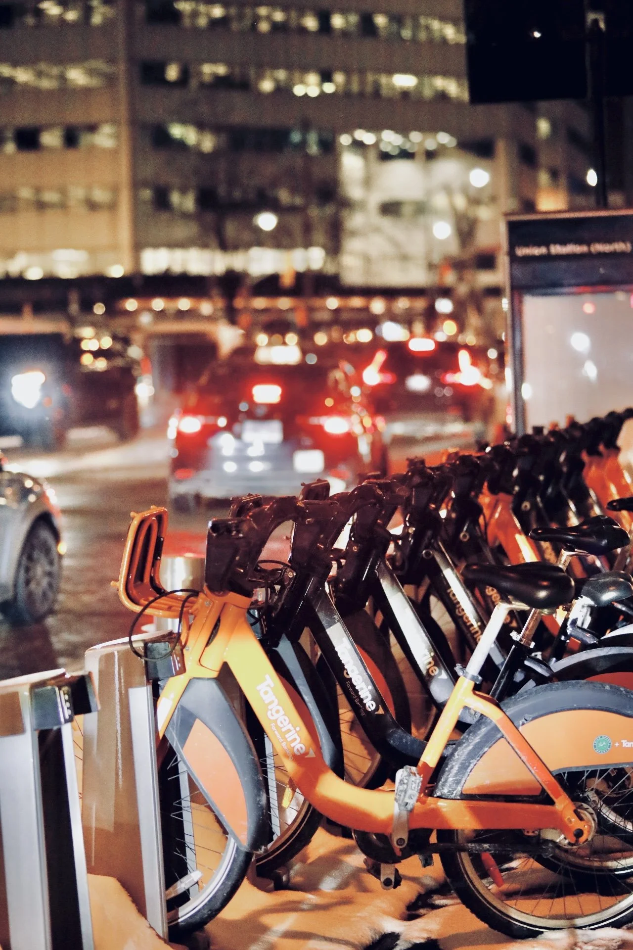
After the Ride @Solomon D Crowe
Bike Share Toronto bikes line a downtown station on a winter night—an everyday symbol of a city shifting from storing cars to sharing motion, and the unanswered question of what happens to shared fleets when they age out.
Toronto’s bike-share boom is changing how the city moves. The harder question is what happens when the boom becomes a backlog.
At street level, the future rarely arrives with a ribbon-cutting. It shows up quietly, in a row of identical bikes waiting under office lights, while traffic inches past and winter air turns every breath into something visible. In downtown Toronto, Bike Share stations have become as normal as crosswalk buttons—part of the city’s everyday machinery, a utility you don’t notice until you need it. One tap, one unlock, and the distance between “I’m stuck” and “I’m moving” collapses into a few minutes of rolling momentum. It’s the kind of convenience that feels inevitable the moment it works: why wouldn’t every city let people borrow motion the way they borrow Wi‑Fi?
But every “inevitable” urban trend has an afterlife. The first life is glossy: ads, apps, speed, the idea that friction can be rented away. The second life is quieter, less photographed, more expensive: maintenance yards, broken parts, battery storage, retirement schedules, and the slow realization that a city doesn’t just deploy mobility—it inherits it. That’s the question waiting behind the orange-and-black fleet lines across Toronto: not whether bike share is popular (it is), not whether e-bikes are coming (they are), but what happens when the craze cools, the hardware ages, and the curb becomes a storage problem instead of a solution.
The instinct is to reach for hyperbole—trillions of bikes—because the feeling is accurate even when the math isn’t. The real global number is still staggering. One of the most comprehensive public counts, the Meddin Bike‑sharing World Map 2024 report, estimates that as of the end of 2024 there were 9,278,605 shared bikes across 2,145 systems, spanning 1,700 cities in 92 countries. That’s not a niche mobility experiment; it’s a worldwide layer of infrastructure—millions of frames, wheels, docks, locks, chargers, screens, bolts, brackets, and increasingly, lithium‑ion batteries. Even if the boom never “ends” in a dramatic way, these systems will still cycle through generations of equipment. Bikes wear out. Technology changes. Contracts shift. Operators consolidate. The question isn’t if there will be an afterlife; it’s whether cities plan for it while the ride is still fun.
Toronto, for the moment, is still in the fun phase—because the numbers keep going up. City reporting on cycling in 2024 described Bike Share Toronto milestones that read like a market report: 6.9 million trips in the year, with 1.1 million e‑bike trips (up from roughly 400,000 the year before), and a 35,000‑trip daily record in September 2024. That’s not a fad; that’s a behavioural shift. And the planning documents suggest the city expects the shift to deepen. A 2030 growth strategy briefing projected that in 2025 Bike Share Toronto would operate 1,060 stations and 10,251 bikes, including 2,319 e‑bikes, with ridership on track for 8.1 million trips—the highest in program history. The system is expanding precisely because it’s being used, and because in a city where traffic is relentless and transit can feel crowded or delayed, a bike is a rare thing: individual speed in public space.
What makes Toronto’s story more interesting than a simple “bike share is growing” headline is who runs it. Bike Share Toronto is operated by the Toronto Parking Authority—the same municipal organization behind Green P parking. The Toronto Parking Authority’s own reporting frames its job as connecting people to mobility services through tens of thousands of parking spaces, EV charging, and a large bike share network. In other words: the agency that monetizes the right to stop also operates one of the city’s strongest tools for moving past stopping altogether. Toronto, in miniature, is learning to hold two truths at once: cars still matter, parking still funds things, and yet the street is too valuable to belong to one mode. Bike share is part of the city’s attempt to give the curb a second purpose—less storage, more circulation.
And yet, history has a way of reminding cities that circulation can turn into accumulation if growth outpaces stewardship. The cautionary tale is not theoretical. In the late 2010s, images from China became the global symbol of dockless micromobility’s worst-case scenario: vast impound lots, mountains of abandoned bikes, fields of metal that looked like an industrial-scale hangover after a venture-fuelled party. The Atlantic documented gigantic piles of impounded, broken, and abandoned bicycles—“bike graveyards”—that appeared after companies scaled too fast and cities struggled to regulate the flood. Other outlets chronicled the same phenomenon from different angles, describing how complaints, bankruptcies, and enforcement actions left cities sorting through the physical leftovers. The bikes became a form of urban archaeology: proof that “disruption” isn’t only a software story; it’s also a materials story. Steel and rubber don’t evaporate when a business model does.
Toronto is not on the same trajectory as those dockless oversupply disasters, and it’s important not to force a false equivalence. Bike Share Toronto is a docked system with planned station deployment and a public operator. The bikes are not being dumped into the city like confetti; they are being installed in a network designed to be counted, serviced, and rebalanced. That matters. It is exactly the kind of governance the Chinese “graveyard” era lacked. But the reason the graveyard precedent still belongs in a Toronto editorial is psychological: it places a bright warning sign at the end of the trend line. It asks, What is the lifecycle plan—before the fleet becomes old enough to become inconvenient? It asks, Who owns the afterlife: the operator, the city, the manufacturer, or the neighbourhood that wakes up one day with a pile of obsolete equipment?
Because the e‑bike shift raises the stakes. A pedal bike at end-of-life is a recycling and logistics problem. An e‑bike is a recycling, logistics, and safety problem—because now the most valuable and volatile component is a battery. Cities already treat lithium‑ion batteries as hazardous waste for good reason. Toronto’s own public safety guidance is blunt: lithium‑ion batteries should not be placed in garbage, recycling, or organics bins; they are considered household hazardous waste and should go to proper drop‑off depots or collection events. That’s written for household devices, but the principle scales: batteries require controlled handling, storage, and end-of-life pathways. As bike share electrifies, “what happens when this ends?” becomes “what happens to thousands of batteries when they age out?” This is the part of the story that tends not to trend—until something goes wrong.
The uncomfortable truth is that modern mobility has an invisible back room. On the street, the system feels simple: bikes appear, riders disappear, docks fill, docks empty. Behind the scenes, the system is a moving factory. Bikes get damaged. Parts fail. Wheels get knocked out of true. Locks jam. QR stickers peel. Winter salts metal in ways summer riders never notice. The station that looks full at midnight can be empty at 8 a.m. because demand is directional, tidal, predictable only in aggregate. And so the operator rebalances—trucks, staff, routing software, midnight shifts—moving bikes the way a grocery store moves inventory. It is labour and logistics that make “shared” feel effortless. That labour is also where end-of-life gets decided in practice: at the moment a technician marks a frame as “repairable,” “donor,” or “retire.”
This is where the “what do we do with all these bikes” editorial finds its emotional core. It’s not a doomsday piece about a trend collapsing. It’s a piece about stewardship in an age that treats hardware like an app update. Bike share’s magic is that it turns ownership into access: no storage in your condo, no repairs in your hallway, no theft anxiety if the system is robust. But the trade is that responsibility doesn’t disappear—it consolidates. Someone is still owning the problem, just at city scale. The question is whether Toronto—and cities watching Toronto—want that ownership to be intentional (planned retirements, recycling contracts, refurbishment cycles), or accidental (warehouses full of obsolete bikes, batteries stored because disposal is expensive, public frustration when bikes vanish overnight due to a failed contract or a financial shock).
Financial shocks are not hypothetical either—especially outside publicly operated systems. In the broader shared micromobility world, instability has been a recurring theme. NACTO’s 2023 shared micromobility reporting described bankruptcies and layoffs among private operators and noted that multiple cities in North America lost shared micromobility programs abruptly. That matters to this editorial even if Toronto’s system is structurally different, because it reveals a simple lesson: when a city relies on shared vehicles, end-of-life planning isn’t only an environmental ideal. It’s continuity planning. It’s “what happens to equipment and service if an operator changes, a contract ends, or a business model stops penciling out?” It’s making sure the public doesn’t wake up to missing bikes—or worse, abandoned ones.
So what do cities do, practically, when the boom becomes a backlog? The answer is not one thing; it’s a hierarchy of outcomes, and the best cities aim high on the ladder.
At the top is repair and redeployment—the quiet workhorse of circularity. A system that can replace key parts quickly, standardize components, and keep frames on the road longer reduces waste and lowers total cost. This is where “design for repair” stops being a slogan and becomes procurement criteria: modular components, easy-to-service drivetrains, predictable fasteners, durable coatings, and inventory strategies that don’t rely on rare parts. A bike share system can be built like a consumer product meant to be replaced, or like civic equipment meant to be maintained. The difference shows up years later, not on launch day.
Next is secondary use—the pathway most people never see. Bikes or components that no longer meet fleet standards can still have life in training programs, community repair shops, or controlled resale channels—if the operator designs a safe and ethical exit route. This is where the editorial can be honest without being alarmist: reuse is not always simple, because liability and quality control are real. But a city that can clearly explain what happens to retired assets tends to earn more trust than a city where equipment simply vanishes.
Then comes materials recovery—recycling. This is where the story gets harder, because not everything is easy to recycle, and the economics can be brutal. Mixed materials, proprietary plastics, embedded electronics, and composite parts can turn “recycling” into “downcycling” or landfill. Which is why the editorial shouldn’t pretend there’s a clean ending unless the city demands one up front. Circularity is most effective when written into contracts: minimum recycled content, take‑back obligations, disassembly standards, and reporting requirements that show how many bikes were refurbished, how many were scrapped, and where the batteries went.
Batteries deserve their own paragraph because they are the hinge between a bike-share boom and a waste-management nightmare. The good news is that battery take‑back and recycling pathways are becoming more visible. In 2025, Lime announced a partnership with Redwood Materials aimed at circular battery recycling for its micromobility batteries in multiple countries, framing it as a step toward keeping battery materials in circulation. Independent reporting described the same relationship in practical terms: batteries from e‑bikes and scooters sent for materials recovery of critical minerals. This is not a Toronto-specific program, but it matters as a model. It signals that “battery afterlife” is becoming a defined industry rather than an improvised cleanup. It also suggests what cities should start requiring as e‑bike fleets expand: documented recycling partners, chain-of-custody handling, and public transparency about end-of-life volumes.
And then there is the outcome nobody wants but every city must be designed to prevent: the graveyard. Not because Toronto is destined for it, but because graveyards happen when incentives reward rapid deployment and ignore retrieval, when contracts end without a transition plan, when enforcement and storage become reactive, and when the public pays for the leftovers in space, mess, and trust. The Atlantic’s bike graveyard images became a global symbol precisely because they were so physical: you could see, from the air, what “growth at all costs” looks like when the costs arrive. Cities don’t get graveyards because they wanted them. They get them because nobody priced in the ending.
A solutions-forward ending, then, isn’t a lecture. It’s a set of practical choices that can be made while the bikes are still new enough to feel like progress.
First: procure for the afterlife, not the launch. If a city is buying or contracting for thousands of bikes and batteries, the contract should require end-of-life plans the way buildings require fire exits. Who takes the bikes back? Who pays for recycling? What percentage must be refurbished versus scrapped? What reporting is required? What happens if an operator changes? These are not ideological questions; they’re operational ones.
Second: design for repairability and modular upgrades. The future isn’t just “more e‑bikes.” It’s a rolling cycle of upgrades: better batteries, better motors, smarter locks, new app interfaces. A system designed to swap modules can avoid retiring whole bikes just because a single subsystem is outdated. The environmental benefit is real, but the economic benefit is often what gets policy across the finish line: fewer total replacements, less storage, less disposal, less panic.
Third: build battery pathways into the city’s existing safety and waste infrastructure. Toronto already tells residents not to throw lithium‑ion batteries in the garbage and directs them to drop-off depots. The same clarity should exist for fleet batteries—publicly documented, auditable, and designed to prevent storage bottlenecks. The more e‑bikes a city deploys, the more the battery ecosystem matters: collection, safe transport, secure storage, and verified recycling.
Fourth: tell the truth in public. Trust is built when systems admit their lifecycle. If Bike Share Toronto is breaking records and expanding fast—and official planning suggests it is—then publishing a simple annual “afterlife report” becomes a powerful act: number of bikes refurbished, retired, recycled; number of batteries replaced and where they went; the average lifespan of a bike; what happens to docks and station hardware when locations change. Toronto already shares ridership milestones and growth strategy. The next step is making the lifecycle visible, so the system feels less like a magic trick and more like a civic service with accountability.
Finally: remember that the point is the street. Bike share is not a trend because bikes are trendy. It’s a trend because cities are crowded and people need options that make them feel capable again. The best mobility systems don’t end in a pile; they end in continuity. They build the city’s confidence that it can adopt new tools without being buried by old ones. That’s the real promise of the row of bikes under downtown lights: not just that they can get someone home faster tonight, but that the city can expand choice without leaving a scar on the curb when the next version arrives.
On a winter night, the bikes wait in a tidy line, as if order is easy. Traffic blurs past. Office windows glow. Somewhere a rider unlocks a bike, glides into the grid, and disappears into the city’s moving parts. That is the visible story. The invisible story is everything that happens later—when the bike comes back, when the battery weakens, when the frame gets retired, when the system upgrades, when a contract ends, when the city decides what happens to thousands of objects it once placed so confidently at the edge of the sidewalk. The editorial question isn’t whether the boom will end. The question is whether Toronto—and every city watching Toronto—wants its mobility future to be remembered for freedom… or for leftovers.
The Price of a Pause: What Green P Reveals About Downtown Toronto
A winter sidewalk, a glowing green “P,” and the simplest urban desire: to stop, briefly, without consequence. In downtown Toronto, paid parking reveals a larger story about time, trust, and who gets the curb.
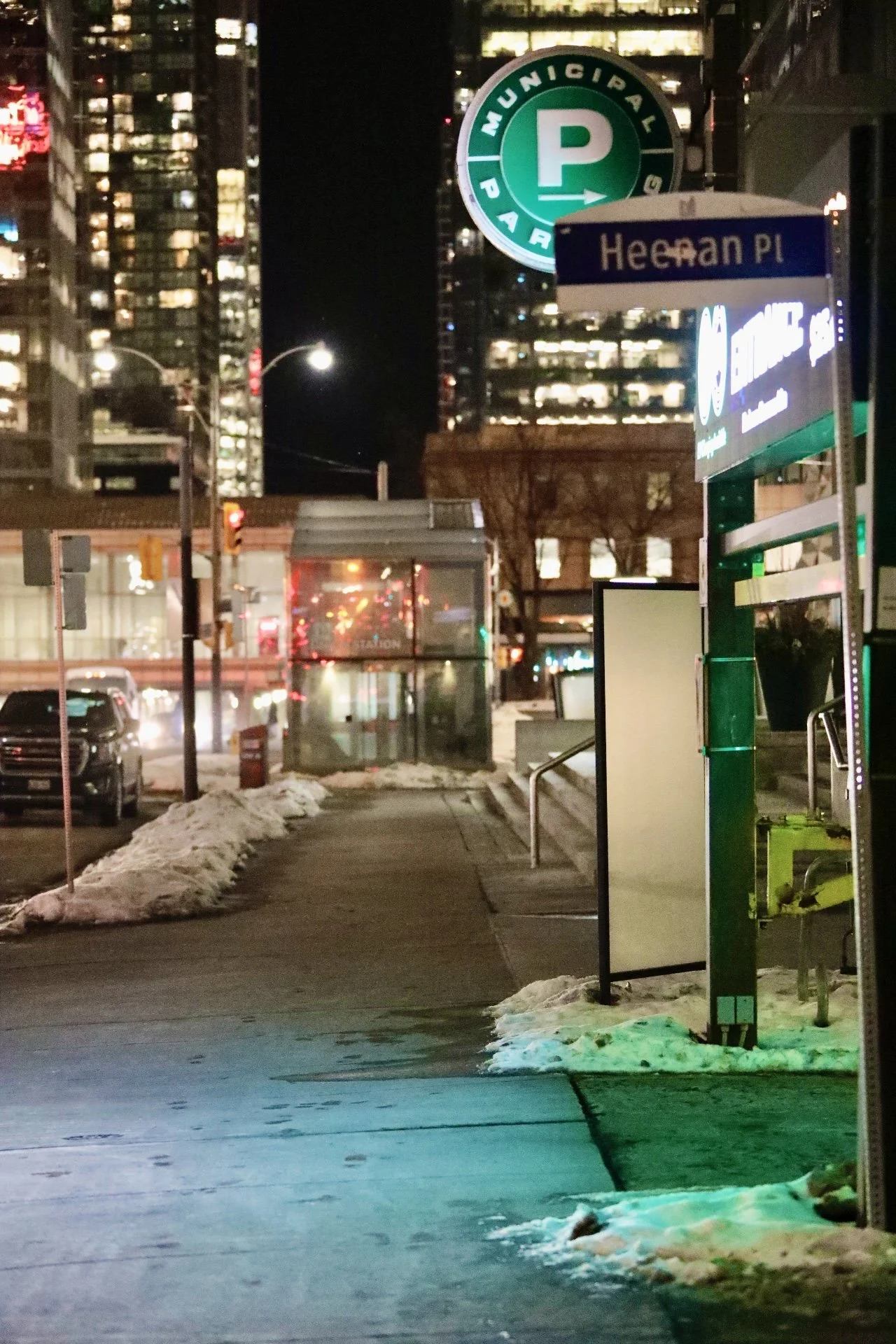
Green P, After Dark — Downtown Toronto @Solomn D Crowe
A Green P “Municipal Parking” marker glows above a winter sidewalk in downtown Toronto, where the simplest promise—a place to stop—has become a daily negotiation between time, technology, and the ever-tightening value of curb space.
There are cities that greet you with a skyline, and cities that greet you with a problem to solve. In downtown Toronto, the first handshake is often a steering wheel, the second is a slow scan for signage, and the third is an unspoken bargain: How much will you pay to be here—right here, right now—without moving? In winter, the bargain is louder. Snow narrows the street the way deadlines narrow a calendar. The curb becomes less a border than a battlefield of inches, and a glowing green “P” can feel like a lighthouse that doesn’t promise safety—only permission. Permission, in Toronto, is rarely free.
Parking is a mundane verb, but in a major city it behaves like a philosophy. It tells you what a place values, what it fears, and how it imagines the future. Toronto’s Green P isn’t just a sign; it’s an interface—between residents and visitors, between analog habits and app logic, between the city’s need for order and the human need for arrival. The Toronto Parking Authority (the agency behind Green P) sits at the intersection of mobility and money: it operates municipal on‑street pay-and-display parking and off‑street facilities, and it’s also the agency that runs Bike Share Toronto. The scale is not small: TPA describes a network of roughly 62,000 parking spaces—about 21.5K on‑street and 41K off‑street—plus EV charging and bike share infrastructure woven through the city’s daily movement.
That scale matters because it changes the emotional temperature of the debate. When someone complains about parking, it sounds like a personal grievance. But parking, at this scale, is a system—and systems have incentives. In 2023, TPA reported $143.6M in total revenue and $38M in net income, returning $31.9M to the City in dividends. In a city where budgets are always a tug-of-war, parking becomes more than a convenience; it becomes a revenue stream dressed up as a service. The 2025 operating budget notes a formal income-sharing arrangement—75% to the City / 25% retained by TPA—and projects $186.095M in revenue, driven by rate changes, transaction growth, and expansion in permits, EV charging, and bike ridership. A Green P sign, in other words, isn’t simply a direction—it’s a ledger entry waiting to happen.
This is why the conversation around downtown parking keeps returning, year after year, like traffic at rush hour. People don’t only resent paying. They resent uncertainty: the sense that they can do everything right and still get punished. They resent friction: the five minutes of circling that becomes fifteen, the small errand that becomes a minor odyssey. And they resent inconsistency: the feeling that the rules are changing mid‑sentence. That resentment is not abstract; it’s measurable in rate hikes, policy pilots, and the growing distance between what a city says it wants—less congestion, more transit, more walkability—and what it still funds with remarkable reliability: the right to occupy curb space.
By the end of 2024, Green P publicly framed new pricing as a mobility tool: rates “set to keep Toronto moving,” encourage turnover, and balance availability throughout the day. Beginning in January 2025, new Green P rates were scheduled to take effect across Toronto. Coverage of the proposed increases made the impact legible: a 25‑cent hourly rise on more than 21,600 metered spaces, with on‑street hourly rates already ranging high enough in dense areas to make an evening out feel like a meter is sitting at the table with you. Global News described the shift as the second metered-rate increase in two years, with most fees rising by 25 cents if approved, and outlined the way Toronto’s rates vary by zone—an invisible map of desirability and demand.
Rate increases are never just about numbers. They are about the story a city tells itself when it decides what scarce things should cost. Toronto’s case is especially telling because it’s not only increasing rates; it’s also modernizing how it collects them—and those two moves together create a particular kind of pressure. Pay more, and do it differently. If the price is the first shock, the method is the second. Toronto has been moving toward cashless and app-first payments for years, and the city’s own reporting shows the direction of travel: CityNews noted that Green P app usage grew from 49% in 2016 to more than 75% in 2023, with over 1.6 million subscribers, and projections toward 85% adoption by the end of 2025. That’s not a niche preference anymore; it’s the default interface for parking in large parts of the city.
The shift to mobile-only zones makes the trend feel like policy rather than preference. A one‑year pilot, approved by Council, introduced 13 “Mobile Only Zones” in downtown Toronto and North York—areas where app usage was higher and the supply of spots thinner. A smartphone becomes the new meter head. A QR code or “Text to Park” becomes the new quarter. For many people, that’s friction removed: no lining up behind someone feeding coins, no guessing whether a machine is broken, no sprint back to a windshield to avoid a ticket. But modern convenience has a shadow: exclusion. CityNews explicitly raised concerns about people without access to technology—older residents, lower‑income drivers, anyone whose phone is dead at the wrong moment—and it’s the kind of concern that turns a service upgrade into an equity question.
The irony is that, even as the city pivots toward mobile, it still spends heavily on the physical machinery of paid parking. CityNews reported that the Parking Authority was continuing to replace aging on‑street machines—$2 million spent to replace 225 machines, with thousands more to go and costs projected to escalate significantly—despite acknowledging that some machines were not generating enough revenue to cover operating and capital costs. The curb, in Toronto, is being asked to be two things at once: a modern, cashless platform and a legacy system built of metal boxes. That tension isn’t just bureaucratic—it’s what people feel when they arrive somewhere and discover the rules exist in two timelines.
And then there is the third pressure: trust. In a city this dense, the parking experience is often the first moment you hand your attention—and your money—to a system you can’t see. When that system fails, the resentment becomes personal quickly, because the failure feels like a trap. In July 2024, CityNews documented a very specific kind of failure: Green P location numbers posted incorrectly in Toronto’s Cabbagetown, leading to drivers receiving tickets even though they had paid through the app. This wasn’t someone overstaying the clock. It was a mismatch between the city’s signage and the app’s logic—a modern form of bureaucracy, where your receipt exists but the system disagrees with itself.
Once you understand that story, the Green P sign changes meaning. It’s no longer only a marker of availability. It’s a test of compliance. It asks: Did you choose the right zone? Did you type the right plate? Did the app reflect what the sign said? And if you fail—whether by mistake or by system error—the burden shifts to you to prove you were right. Green P itself advises drivers how to contest a violation when they have proof of payment—screenshots, email receipts, customer service contacts—because the system presumes disputes will happen and requires documentation to unwind them. In a city where time is already expensive, the dispute process becomes a second meter running in the background.
That dispute process is not a quick catharsis. The City of Toronto’s own parking-violation dispute page includes a line that reads like a quiet warning: “Current turn-around time is up to 10 months.” Ten months is long enough for a season to change twice, long enough for a person to forget what the night looked like when they parked, long enough for a small injustice to calcify into a story told at dinner parties and office kitchens. The point isn’t that every ticket is wrong. The point is that the emotional experience of enforcement is shaped as much by process as by outcome. When the process is slow, the system feels less like order and more like attrition.
Underneath the daily irritations—rates, apps, tickets—there is a deeper truth: the curb is one of the most valuable pieces of public real estate in Toronto. It must serve many masters at once. Drivers want it. Cyclists need it protected. Couriers treat it like oxygen. Transit vehicles require clear lanes. Accessible parking is not a luxury—it is basic dignity. A curbside management study prepared in the Toronto context describes a long list of competing curbside users—drivers, cyclists, pedestrians, couriers, taxis, transit, accessible services, hotels, emergency services—because the curb is where a city’s different modes of life collide at low speed. Parking isn’t just parking; it’s a proxy fight over who gets to touch the city easiest.
This is why downtown parking doesn’t merely frustrate. It produces a kind of low-grade civic anxiety. If you are late for dinner because you can’t find a spot, you blame yourself at first, then the city, then the idea of downtown itself. If you circle long enough, your frustration becomes indistinguishable from congestion. The city tries to solve congestion with pricing and turnover; the driver experiences pricing as punishment and turnover as pressure. Both sides are reacting rationally to scarcity. But the story most people live is not “scarcity management.” It’s “I’m paying more to feel less welcome.”
And yet, to tell the truth, there is another side—one that’s harder to hold in your hand but easier to see on a balance sheet. The Toronto Parking Authority is not a marginal operation; it’s a significant municipal business, and its financial performance is tied to how the city funds other priorities. A 2025 report to the TPA Board stated that net income for 2024 was $44.7 million, with total revenue at $165.6 million—described as a “historical high”—and noted that parking revenues reached 97.2% of pre‑pandemic (2019) levels as businesses adapt to hybrid work. Parking revenue, in other words, is part of Toronto’s post‑pandemic recovery narrative. Even if fewer people commute five days a week, the city still depends on the monetized “pause” to keep certain gears turning.
This is where gratitude can enter the frame—carefully, without pretending frustration isn’t real. People can be grateful that a city maintains parking inventory near hospitals, venues, and dense commercial corridors, or that municipal parking provides predictable options compared to private lots with surge pricing. They can be grateful that a public agency returns dividends to the city, or that the system is investing in modernization that reduces wasted time. The TPA annual report frames its mission in the language of “choice, ease, and speed” and points to the integration of parking with EV charging and bike share as part of a broader mobility network. If you zoom out far enough, Green P isn’t just a place to leave a car—it’s one node in a city’s attempt to choreograph movement.
But zoom back in, and the lived experience remains messy. Downtown Toronto is where private urgency meets public policy. The curb is where everyone’s plan collides with everyone else’s schedule. The reason Green P content performs well online—why people click, share, and argue about it—is that parking is one of the few municipal services most people encounter in a moment of stress. Nobody searches “Green P” when life is calm. They search it when they’re late, cold, lost, or furious. They search it when the city’s abstractions become tangible, when the price of being present is no longer metaphorical.
So if a Green P sign glows over a winter sidewalk, it’s doing more than advertising spaces. It’s broadcasting a question Toronto is still learning to answer: Who is downtown for, and how do we manage arrival without punishing it? Rate increases can be defensible; turnover is real; congestion is costly. Mobile payments can be smarter; the quarter economy is fading; receipts are easier to prove than memories. But trust must be earned with clarity, and clarity is built with signage that matches reality, processes that move at human speed, and technology that doesn’t turn honest mistakes into fines.
The best editorial angle isn’t “parking is bad” or “parking is necessary.” It’s that parking is a mirror—an unglamorous reflection of how a city treats time. Toronto is a city of ambition and velocity. It sells possibility in condos and careers and culture. And yet the smallest, most common transaction—the purchase of a pause—can still feel like a gamble. If Toronto wants downtown to be loved, not merely endured, it will have to treat the curb not as a cash register or a complaint factory, but as a public space that people share under pressure. The “P” will keep glowing either way. The only question is whether it feels like an invitation—or a warning.
Between Stops
A winter night in Toronto turns transit into a ritual—red lights, overhead wires, steam at street level, and a streetcar carrying the city forward one stop at a time. In a growing downtown, “getting there” has become the story.
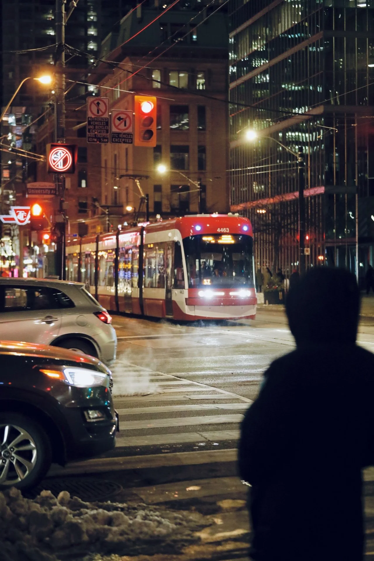
Between Stops — TTC Winter Night @Solomon D Crowe
A TTC streetcar pauses at a downtown red light on a winter night—steam rising at street level and overhead wires tracing the city’s grid as Toronto’s shared rhythm waits, then moves.
Toronto’s winter streetcar, and the city’s race against its own clock
Toronto at night is a geometry lesson taught in light. Overhead wires stitch the sky into a grid; glass towers hold hundreds of private lives behind illuminated rectangles; traffic signals pulse like a heartbeat the whole downtown core can feel in its feet. Winter tightens everything. It sharpens the air, narrows the margins, turns the curb into a low ridge of snow that forces you to step where the city allows. And then a streetcar arrives and the scene becomes something else entirely—less like a commute, more like a ritual. Steel on rail, red-and-white bodywork sliding forward with the patience of a machine built for repetition. A pedestrian in a hood becomes a silhouette, paused at the edge of the intersection, the city’s human punctuation mark. Steam lifts from street level and the pavement shines with that particular wet gloss Toronto gets when snow has half-melted and refrozen into something between slush and mirror. The light is warm, but the night isn’t. The tension lives in that contrast: a city designed to move, temporarily held by a red signal, waiting for permission to continue.
The streetcar is where Toronto reveals its true scale—not the skyline scale, but the people scale. Subways disappear you; cars isolate you; streetcars put you on display, at street height, in the same weather as everyone else. That’s why a streetcar photo reads as instantly “Toronto” even to someone who can’t name the intersection: it’s the visible thread between neighbourhoods, the connective tissue the city still wears on its sleeve. The TTC itself describes a system that is quietly enormous: 11 streetcar routes spanning 308 km, carrying over 34.5 million streetcar trips in 2024. And those trips aren’t a footnote to the subway; they’re a major share of how Toronto actually works day to day. In 2024, the TTC reported roughly 204 million bus trips, 181 million subway rides, and about 35 million streetcar trips—a reminder that Toronto’s public life runs on surface movement as much as it runs underground. You can feel that truth in winter, when the city’s choices become physical. When you choose the streetcar, you’re choosing shared space and shared timing. You’re choosing to be part of the city rather than passing through it sealed behind glass. It’s not just transportation. It’s an agreement that, in a place as busy and expensive as this, public movement still matters.
But that agreement is fragile, because Toronto’s streetcars have always carried a contradiction: they’re high-capacity vehicles forced to behave like traffic. They glide on rails, yet they’re constantly negotiated by lanes, left turns, delivery trucks, and the endless micro-claims on curb space that add up to systemic delay. In the scene, the signage is doing what Toronto signage always does—trying to engineer order after the fact. Authorized vehicles. Exceptions. Restrictions. Rules layered on rules because the street is contested territory. The irony is that streetcars are supposed to be the “clean” answer to urban circulation—predictable, efficient, high throughput—and yet their biggest enemy is the same thing that clogs every other mode: congestion. That conflict is why the TTC’s streetcar corridors are such high-stakes streets. Look at the ridership on the major lines and the argument becomes obvious. The TTC’s own operating statistics show how heavily these routes are used: the 504 King corridor averages about 61,000 weekday boardings, while the Queen corridor (501/507/508 combined) sits around 42,000 on an average weekday (based on November 2024 data). These aren’t boutique tourist rides. These are working arteries—moving hospitality staff, office workers, students, families, night-shift workers, and everyone in between. When a streetcar is delayed, it isn’t just one vehicle behind schedule; it’s a ripple that touches thousands of evenings—late dinners, missed connections, extra money spent on alternative rides, and the slow erosion of trust that makes people decide they need a car they can’t really afford.
Toronto has experimented with how to protect the streetcar from the very street it runs on, and the most famous example is King Street. The King Street Transit Pilot began November 12, 2017 with a simple but radical proposition: stop letting through-traffic treat the streetcar’s path as optional. The results were not framed as ideology; they were framed as performance—what the corridor delivered when private automobile interference was reduced. City reporting on the pilot summarized the impact in plain language: faster, more predictable transit journeys, improved efficiency and reliability for streetcar operations, and more people taking transit in the corridor. If you want a story about “what works,” Toronto has already run the lab. The pilot showed that you don’t need a futuristic vehicle to improve a city; sometimes you just need to decide, in a specific place, that the movement of people outranks the convenience of cutting through. It also proved something deeper about Toronto: people will take transit when it behaves like a promise. When it’s reliable, when it doesn’t feel like a gamble, when it doesn’t punish you for trusting it.
And then the internet did what the internet does: it turned a system problem into a simple narrative almost anyone can understand. In the past year, a Toronto runner gained attention for outrunning streetcars, again and again, filming the races and turning the city’s slow points into shareable evidence. It’s viral because it’s absurd—and because it’s recognizable. Everyone who has stood at a cold stop watching a streetcar crawl forward in a line of brake lights understands the emotional math instantly: if a human being can beat the system on foot, the system is not operating at the dignity level a modern city should accept. The runner’s point—reported in mainstream coverage—wasn’t “hate the TTC,” but that streetcars lose time in the core because they’re forced to behave like cars: stalled by signals, blocked by turning vehicles, interrupted by the small chaos of downtown. Virality, in this case, isn’t shallow. It’s a blunt form of accountability. It collapses a complicated set of engineering issues—signal priority, lane design, enforcement, construction scheduling—into one undeniable image: a streetcar being beaten to the next stop by someone in running shoes.
The more interesting part is what happens after the meme. Toronto has begun translating that frustration into physical change you can see from the curb. One of the clearest examples is RapidTO, the city’s approach to transit-priority lanes and corridor improvements. On Bathurst Street, for example, the plan includes converting lanes to priority streetcar lanes using new signage, pavement markings, and red paint—an attempt to carve out space where transit can operate without being constantly interrupted by cars. This is not a glossy “smart city” fantasy. It’s paint, signs, and rules—unromantic tools aimed at a romantic outcome: making the city feel smaller, more navigable, less exhausting. And the urgency is being sharpened by a deadline Toronto can’t ignore. With the 2026 FIFA World Cup bringing global crowds and concentrated movement demands, reporting has highlighted plans to increase service so streetcars run roughly every five minutes during celebrations on key corridors, while the TTC works through concerns about whether the overhead power and infrastructure can support that level of ramp-up. Big events don’t create city problems; they reveal them under brighter light. When a city knows the world is coming, it stops tolerating bottlenecks it has normalized for years.
Fleet and frequency are the other side of the story—the part that doesn’t photograph as cleanly, but determines whether the beautiful night scene becomes a functioning network or a slow-motion frustration. In early 2026, the TTC marked the completion of a major streetcar procurement: 60 new streetcars delivered, bringing the fleet to 264 vehicles—a reported 30% increase intended to support more reliable, accessible service across the city. This matters in a winter-night editorial because you can feel the difference between a city that is “trying” and a city that is “equipped.” More vehicles, in theory, means less crowding, better headways, and less of the bunching phenomenon where you wait a long time and then three streetcars show up like a punchline. But equipment alone isn’t the whole fix. A streetcar fleet is only as effective as the infrastructure under it: track condition, overhead wire health, signal timing, and the city’s willingness to defend transit priority when the curb becomes a battleground. Toronto knows this, which is why so much transit improvement work looks less like a ribbon-cutting and more like invisible maintenance—overhead systems, intersections, and the unsexy systems that determine whether “every five minutes” is a promise or just optimistic copy.
That’s why this winter TTC scene lands as more than urban atmosphere. It’s a snapshot of Toronto’s central tension right now: a city growing faster than its patience. The streetcar at a red light isn’t just waiting for permission to go; it’s waiting for the city to decide what it values. Because every intersection is a values test. Who gets to move first: the largest vehicle carrying the most people, or the private vehicles that consume the most space? Who owns the curb: deliveries, ride-hails, parked cars, or transit stops that serve tens of thousands? How much public inconvenience is Toronto willing to tolerate in order to improve public movement for everyone? Those are governance questions, but they’re felt as human questions: How long will it take me to get home? Will I miss the connection? Will I be late again? Is this city still workable without buying my way out of it? Winter sharpens those questions because cold amplifies time. A five-minute delay on a mild day is annoying. A five-minute delay on a wet, freezing night is existential.
And then the light changes. The streetcar begins to roll. The hooded figure steps forward. The cars adjust, reluctantly, like they’re part of a choreography they didn’t choose but must obey. In that moment, Toronto looks less like a collection of competing lives and more like what it actually is at its best: a shared system, imperfect but capable, where strangers align for a few seconds to let the city function. That’s why streetcars remain such powerful travel imagery. For visitors, they’re a front-row seat to Toronto’s street-level life—neighbourhoods unfolding at human speed, storefronts and towers and street corners threading into a coherent map. For locals, they’re the city’s daily proof that public space can still work, even when it’s stressed, even when it’s cold, even when it’s late. The real editorial point isn’t that Toronto has a streetcar system. The point is that Toronto is still negotiating what kind of city it wants to be: one where movement is a privilege you purchase privately, or one where the shared option is fast enough, frequent enough, and respected enough to feel like the default. In winter, under wires and signal lights, that choice becomes visible. It sounds like steel on steel. It looks like a red-and-white streetcar moving forward—finally—through the downtown night.
Under the Marquee — Fairmont Royal York
Toronto winter sharpens everything—air, pace, and light. Under the Fairmont Royal York’s marquee, downtown turns cinematic: a warm threshold between street noise and sanctuary, where arrivals feel like an event again.
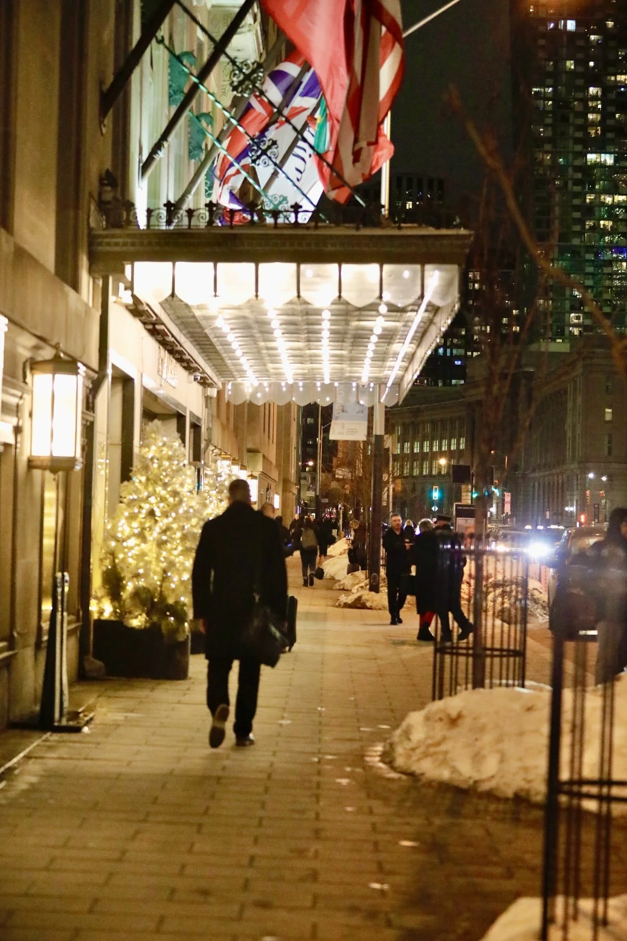
Under the Marquee — Fairmont Royal York
A winter evening on Front Street West, where the Royal York’s canopy lights turn downtown foot traffic into a scene of arrivals-warmth and movement framed in the city’s glow.
Fairmont Royal York, Toronto — and the winter ritual of arrival
Toronto in winter doesn’t greet gently; it announces itself. The air has edges. The sidewalks carry salt and refreeze and the kind of forward motion that makes even a casual walk feel like a commute. Then, right when the street starts to read as purely functional—cars, towers, headlights, deadlines—there’s a canopy of light that changes the entire tone of the block. Outside the Fairmont Royal York, the marquee doesn’t just illuminate the sidewalk; it curates it. People move differently under that glow. Pace softens. Coats loosen. The city’s constant hurry briefly becomes a procession, and for a few yards, Toronto feels less like a machine and more like a stage.
That’s the quiet genius of a great city hotel: it doesn’t simply provide rooms, it creates arrival. The Royal York has always been built around that idea. Long before “downtown lifestyle” was a marketing category, this was a landmark designed to meet the city at its most important threshold—where travelers entered Toronto’s core and needed the first impression to feel certain, capable, and a little grand. It’s why the building still feels perfectly placed: not hidden behind a courtyard, not tucked into a side street, but set directly into the city’s bloodstream, where movement is constant and where a single, well-lit doorway can make the whole metropolis feel legible.
The emotional power of the Royal York at night is that it offers warmth without drama and drama without noise. The flags above the entrance nod to internationalism in the simplest visual language possible, while the row of bulbs under the canopy does what excellent hospitality lighting always does: it flatters, steadies, calms. It’s not the kind of light that screams for attention; it’s the kind that says, you’re safe to exhale here. The lobby may be the famous interior, but the sidewalk is where the story starts—where winter makes everyone look slightly more alone, and the hotel counters with a human-scale glow that gathers strangers into the same scene.
This is what makes the Royal York such a strong subject for travel storytelling: it sits at the intersection of glamour and practicality. In a winter city, practicality matters. Boots, bags, late meetings, last trains, early departures—Toronto runs on schedules, and the streets don’t care how elegant anyone wants to feel. Yet the hotel insists on a different rhythm right at the door. It turns a quick pass-by into a moment worth noticing. It makes an ordinary city block feel like a threshold between two versions of Toronto—the one that works late and moves fast, and the one that still believes a night out should feel like an occasion.
A strong travel editorial doesn’t confuse “luxury” with excess. Luxury, in a city like this, is often control: a dependable entrance, a clear meeting point, a sense that the evening has structure even if the rest of the day didn’t. Under the marquee, the small rituals become visible: arrivals re-centering themselves before stepping inside, couples pausing to decide what the night will be, business travelers moving with that practiced stride that says they’ve done this a hundred times and still appreciate a door that works like a promise. The city beyond is glass and speed; the hotel edge is warmth and order, a place where the cold doesn’t get to dictate the mood.
And that’s the Toronto winter truth: the best nights aren’t only made by what happens inside venues, they’re made in the transitions—sidewalk to lobby, street noise to quiet, cold air to controlled light. The Royal York’s entrance is a masterclass in transition design. The canopy doesn’t simply cover; it frames. It doesn’t simply brighten; it invites. It doesn’t announce itself as “historic” or “iconic” in neon language. It lets the city do what it does, then gently edits the scene into something cleaner, softer, more cinematic.
By the time the block recedes behind you, what lingers isn’t a list of amenities or a brochure-perfect pitch. It’s the feeling that Toronto—so often defined by motion—has a few places that still know how to receive people. In winter, that matters more than ever. Anyone can build a tall building. Not every place can build a moment. The Fairmont Royal York does, night after night: a strip of light in a fast city, turning winter travel into something that feels, for a few seconds, like a classic.
Blue Hour on the Benjamin Franklin Parkway
Blue hour on the Benjamin Franklin Parkway turns Logan Square into an open‑air museum—where the Pennypacker memorial, the fountain, and the Parkway’s Beaux‑Arts grandeur make Philadelphia’s best nighttime itinerary a simple walk.
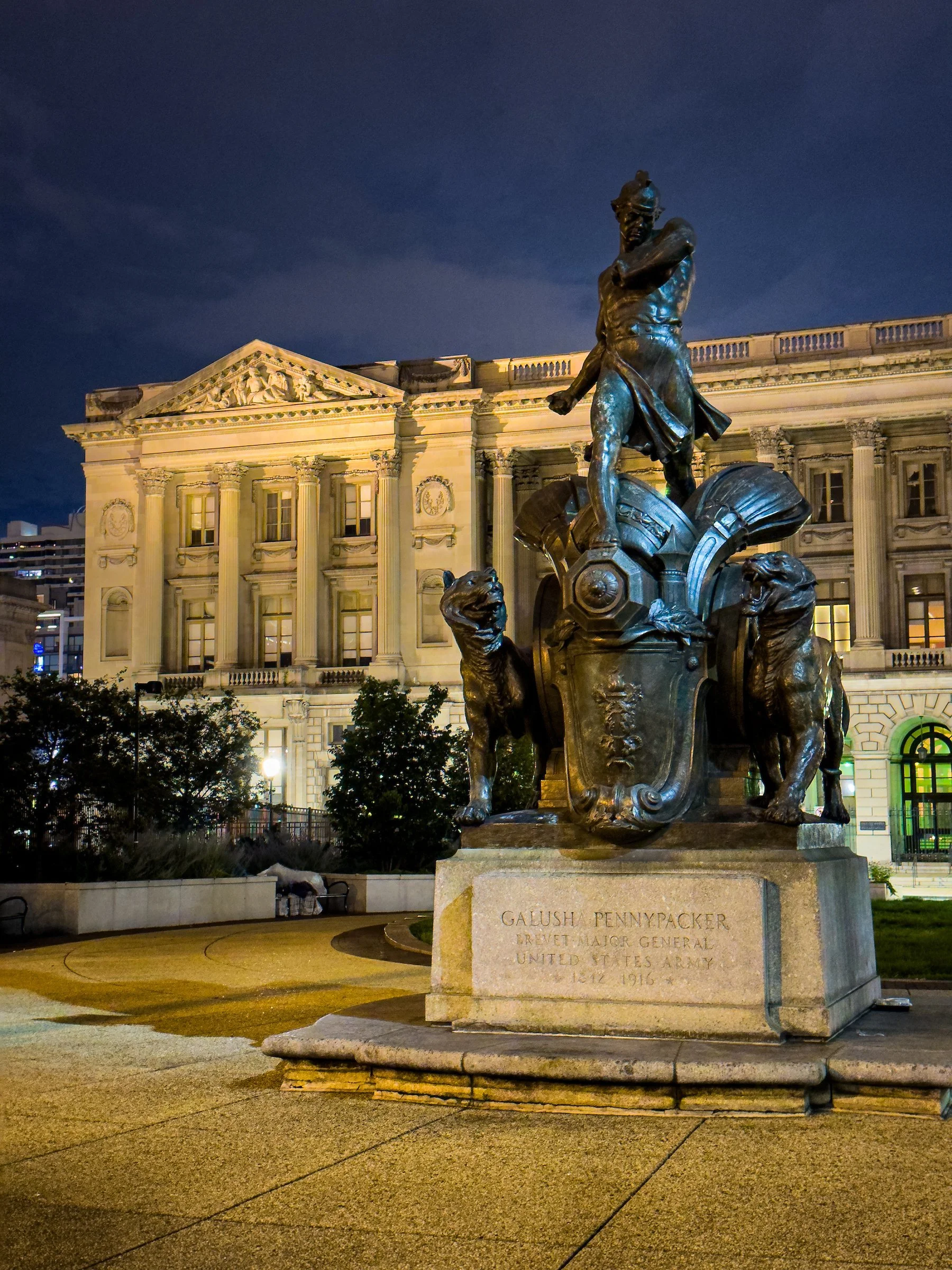
Blue Hour at Logan Square @Solomon D Crowe
The General Galusha Pennypacker Memorial (1934) stands near the Benjamin Franklin Parkway at Logan Square—bronze drama against a deepening Philadelphia sky.
A night walk at Logan Square, where Philadelphia turns its history into atmosphere.
Blue hour in Philadelphia doesn’t arrive like a curtain drop. It arrives like a slow agreement between stone and sky. The day’s sharp edges soften. The traffic noise loses its teeth. Light stops being practical and becomes theatrical—streetlamps and building uplights doing what dusk does best: making familiar places look newly expensive. On the Benjamin Franklin Parkway, that shift is the whole point. This is a boulevard designed not merely to move people, but to stage a city’s cultural confidence—one mile of diagonals and monuments intended to be read like a sentence you can walk through, from City Hall to the steps of the Philadelphia Museum of Art.
At the center of that sentence sits Logan Square—Logan Circle, if you’re speaking in traffic geometry—a civic room with a fountain in its middle and some of Philadelphia’s most commanding architecture at its edges. The Parkway’s designers were never shy about their references: the boulevard was modeled with unmistakable French influence, planned and brought to completion by major figures including Paul Philippe Cret and Jacques Gréber, with the whole composition consciously echoing the Champs‑Élysées. Logan Square was even envisioned as a great “circle” in the spirit of Parisian civic space.
And then there’s the statue—because blue hour needs a protagonist. Near 19th Street and the Parkway, the General Galusha Pennypacker Memorial stands with the kind of dramatic confidence you’d expect from an era when cities believed public art should compete with cathedrals and courthouses. Installed in 1934, it depicts a youthful figure in classical attire stepping forward from an elaborately decorated cannon, flanked by two roaring tigers—a composition that reads less like a polite tribute and more like a scene paused mid‑motion. The work began as an idea developed by sculptor Charles Grafly, and after his death it was completed by his former student and assistant Albert Laessle, who carried the project across the finish line.
If you’re looking for why this monument pops at night, it’s because it’s built on an unusual choice: it refuses stillness. Most memorials want you to stand respectfully in front of them; Pennypacker’s memorial seems to be leaving without you. The tigers don’t behave like ornamental animals—more like a warning that the statue is not interested in being background. In the Beaux‑Arts tradition that shaped so much of the Parkway’s public art, symbolism matters as much as likeness, and the classical costume isn’t a history lesson so much as a statement: this is not one man frozen in time, but a set of ideals the city wanted to engrave into the air.
Pennypacker himself brings a human tension that makes the monument feel oddly contemporary. He’s remembered as a Chester County native associated with being the youngest general to serve in the Civil War—though even reputable sources note debate about his exact birth year, which shifts the arithmetic of “youngest” depending on what record you believe. What’s less debated is his reputation for bravery: he received the Medal of Honor for action at Fort Fisher, North Carolina, in January 1865, a citation that’s blunt in the way official history often is—he led a charge, planted regimental colors, and was severely wounded. The monument’s energy suddenly reads differently with that in mind: not generic heroism, but a biography written early, fast, and hard.
But the real travel story—the one that brings people back to Logan Square at night even when they’re not thinking about Civil War history—is how this single sculpture connects to the Parkway’s larger idea: that culture shouldn’t always require a ticket, a reservation, or a doorway. The Benjamin Franklin Parkway was conceived in the early twentieth century as a City Beautiful project: a grand, European‑influenced boulevard connecting the civic heart of downtown to the city’s premier park and, over time, becoming a district of cultural institutions and a commons for celebrations. The trick of the Parkway is that it functions as both infrastructure and theater. You can cross it in a rideshare, or you can treat it like a curated corridor—an outdoor museum stitched into the city grid.
Blue hour is when that corridor finally feels legible on foot. In the daytime, the Parkway can read as busy: buses, commuters, museum queues, school trips, tour vans doing their loops. At dusk, the traffic stays, but it stops dominating the story. You begin to notice the deliberate composition: the long diagonals, the sightlines, the way buildings hold the boulevard like bookends. You also notice what Gréber and his collaborators wanted Logan Square to be: a place where civic architecture and public art are not scattered accidents, but neighbors introduced to one another on purpose.
That purpose becomes especially clear in the paired Beaux‑Arts civic buildings near Logan Square—part of the Parkway’s French DNA. The planners didn’t just build a boulevard and hope culture would follow; they proposed major civic institutions as anchors, and they did it with direct Parisian references. The Free Library was conceived as one of those anchors, and the Library of Congress’s architectural documentation notes that the Central Library’s design favored French architecture of the seventeenth and eighteenth centuries and drew inspiration from the buildings framing Paris’s Place de la Concorde. The Free Library itself records that the Central Library opened for service at its Logan Square location on June 2, 1927, after years of planning and delays. If you want to understand the Parkway’s atmosphere at night, stand where you can see that architecture and then look back to the Pennypacker memorial: you’re looking at Philadelphia trying, very deliberately, to turn culture into a civic habit.
The reason this works for a feature travel editorial—especially one designed for discoverability—is that it offers the kind of experience people actively search for but rarely describe well: Philadelphia at night, done without clubs, without crowds, without the sense that you’re settling for “what’s still open.” The Parkway after dark is a high‑yield walk because it contains the city’s museum district energy even when museum doors are closed. It’s also a rare urban landscape where the “free” option doesn’t feel like a compromise. You can do it as a slow loop around Logan Square, or as a longer drift up and down the Parkway, letting the skyline change as you move from the center outward. The city gives you a clear spine, and the art gives you stopping points.
This is where Pennypacker becomes more than a statue. It becomes a wayfinding device for mood. There are monuments that disappear into the daytime noise; this one seems to wake up when the light goes low. The bronze holds mixed lighting—streetlamp warmth, building uplight, sky-blue shadows—in a way that photographers recognize instinctively, even if they don’t use the phrase “blue hour.” You don’t need to be a photographer to feel why people pause here. The memorial’s composition is already cinematic: a stride frozen mid‑step, animals caught in a perpetual snarl, the whole mass raised above the sidewalk like a scene lit for a stage.
One of the smartest things Philadelphia has done—quietly, without turning it into a theme park—is to give people a way to hear this outdoor collection, not just see it. The Association for Public Art’s Museum Without Walls: AUDIO program offers an accessible audio layer for sculptures across the city’s public art landscape, including the Parkway. It’s not a single authoritative guide voice; the program is built around “authentic voices”—people connected to the art by experience or expertise—and the Association notes it includes more than 75 audio segments featuring over 160 unique voices, with multiple ways to listen, including via the Bloomberg Connects app and other on-site options. That matters for travel storytelling because it converts a casual night walk into a richer, shareable experience without making it feel forced or overly guided.
Logan Square itself contributes another layer of nighttime gravity: the Swann Memorial Fountain, created in 1924 by Alexander Stirling Calder, sits at the circle’s center like a civic hearth. The Association for Public Art describes it as a memorial to Dr. Wilson Cary Swann and notes that its figures symbolically represent Philadelphia’s waterways—the Delaware and Schuylkill Rivers and Wissahickon Creek—turning geography into sculpture. Whether the fountain is running or not, it defines the space as a place where people naturally gather, linger, reorient, then move again toward whatever their night becomes. In a travel piece, it’s the perfect counterpoint to Pennypacker’s intensity: water and bronze calm at the circle’s heart, then the tigers and stride waiting just off to the side, as if the square holds both serenity and force in the same breath.
A good feature editorial also needs human texture, and the Parkway gives it to you in the hours between dinner and midnight. Blue hour is when locals start reclaiming the corridor for themselves—couples taking the long way home, runners pacing the sidewalks, visitors asking quietly if they’re “still near the museums,” photographers posted at corners where the architecture reads like a postcard without trying. The Pennypacker memorial becomes a meeting point without needing a sign that says so. People use it the way cities have always used statues: as a landmark for rendezvous, as a pause button for conversation, as a momentary substitute for scrolling.
And if you zoom out, the Pennypacker memorial sits inside a bigger, highly searchable truth about Philadelphia: the Parkway is a one-mile cultural axis stacked with institutions and sculpture. Official visitor resources describe it as a diagonal boulevard stretching one mile through the museum district, with major attractions clustered along the route and the Parkway’s French‑inspired design language baked into its identity. That’s why this “after dark” version works as a travel feature—because the daytime itinerary is already obvious. What people crave, and what they search for, is the in‑between itinerary: what to do when the crowds thin, when the city feels quieter, when you want something memorable but not exhausting.
There’s a subtle, almost radical promise inside that: you can experience a city’s cultural backbone without being herded through it. Museums do an essential job, but they also come with scripts—hours, tickets, lines, audio guides, gift shops. The Parkway at blue hour is the unscripted version. You can stand five feet from a monumental work of public art and feel its full scale without anyone telling you where to look first. You can drift from one landmark to another at a pace that matches your mood, not your reservation time. The experience becomes less about consumption and more about attention, which is the most valuable currency a destination can offer now.
Pennypacker’s memorial, in that sense, is a perfect emblem for Philadelphia’s nighttime grandeur because it refuses to be polite. It’s not a gentle civic handshake. It’s a city saying: this is who we are—unapologetically historical, unapologetically designed, unapologetically willing to put drama in the open where anyone can encounter it. The monument’s origin story also carries a quiet Philadelphia signature: the relay between artists, the passing of a concept from Grafly to Laessle, the idea that public work outlives its maker and becomes the city’s responsibility. The Association for Public Art notes the memorial was commissioned by the State of Pennsylvania and the Pennypacker Memorial Commission and is owned by the City of Philadelphia—public art as a long-term civic commitment rather than a short-term installation.
If you want the most honest takeaway from a blue-hour walk here, it’s not a list of “top things to do.” It’s a feeling: Philadelphia is at its most magnetic when it’s not rushing to impress you. The city doesn’t need fireworks when it has proportion, material, and light. Logan Square gives you all three. The Parkway gives you a clear direction. And the Pennypacker memorial gives you a final image that feels like it could only exist here: a young general rendered as myth, tigers at his sides, the whole scene holding its ground against a darkening sky as if daring you to look away.
You leave with the sense that you’ve found a version of Philadelphia that many people miss because they treat nights like a logistical problem instead of a travel opportunity. “What’s open?” becomes the wrong question. The better question is, “What’s beautiful when it’s quiet?” On the Benjamin Franklin Parkway, the answer is waiting at blue hour—bronze and limestone, water and sky, a city’s cultural ambition still glowing long after the doors have closed.
Barefoot Under the Pitons
St. Lucia earns its “ultimate destination” reputation the honest way - through scale, contrast, and calm that can’t be manufactured. Beneath the Pitons, a single day can hold beach softness, volcanic heat, cacao depth, and nights that feel alive without feeling staged.

Barefoot Under the Pitons @Solomon D Crowe
St. Lucia’s west coast turns a simple shoreline walk into a full reset—salt air, quiet water, and the Pitons holding the day in place.
A St. Lucia feature on the kind of luxury you can’t pack: scale, salt, and a day that finally slows down.
St. Lucia doesn’t ease you into wonder—it drops it on your shoulders like a warm towel. One moment you’re moving through the ordinary logistics of arrival, and the next you’re standing at a shoreline where the island’s famous geometry takes over: forested slopes, a protected curve of water, and the Pitons rising with the kind of authority that makes conversation go quiet. The model in your frame isn’t there to “sell” the destination; she’s there because St. Lucia changes the way a person occupies space. You stop walking like you’re late. You stop holding your breath for the next notification. You start moving like the day is yours again, because for once, it is.
The Pitons are not background. They are the island’s signature—two volcanic spires near Soufrière that dominate the west coast and anchor the UNESCO‑listed Pitons Management Area. When people say St. Lucia is the ultimate destination, they usually mean a single thing: you can have romance, drama, and calm in the same frame without forcing it. The mountains give you scale; the sea gives you softness; the rainforest gives you depth; and the villages give you a pulse that isn’t imported. The result is a place where “vacation” stops meaning entertainment and starts meaning permission—permission to return to your senses without needing to explain why you needed it so badly.
There’s a reason the simplest movement—a barefoot walk—lands like a headline here. At home, walking is often just transit between tasks. Here, it becomes a form of arrival. The model’s pace in the sand reads like a subtle refusal of modern speed: no earbuds, no hurry, no performance. The shoreline does what great destinations do: it edits your life down to essentials. Water. Light. Breath. The quiet click of small waves collapsing and retreating. The kind of calm that doesn’t feel like “doing nothing,” but like finally doing the thing your body has been asking for all year.
St. Lucia rewards people who understand that the best itinerary is built around contrasts. Start with the island’s softest contrast: the calm of a bay beneath the Pitons, where the sea behaves like a lake until you step in far enough to feel the temperature shift. Then let the day tilt toward the island’s other personality—its volcanic heart. The Pitons Management Area isn’t only about scenic impact; UNESCO describes a volcanic complex that includes geothermal features such as sulphurous fumeroles and hot springs, with coral reefs covering a large portion of the marine area. That’s the St. Lucia advantage: you’re not choosing between beach and “something to do.” The island stacks experiences vertically—sand at your feet, rainforest at your back, volcano under the road.
Drive south toward Soufrière and you can feel the island’s heat rising through the story. St. Lucia is one of the few places where the word “volcano” isn’t marketing—it’s literally part of the day’s menu. The Sulphur Springs site is widely promoted as the world’s only “drive‑in volcano,” and whether you arrive as a believer or a skeptic, the air makes its case first: mineral tang, warm ground, the sense that the island is still alive beneath the surface. The mud baths are the kind of experience that sounds gimmicky until you’re in it and realize it’s doing something simple and ancient—resetting you by force of sensation.
If you want St. Lucia to feel less like a brochure and more like a place, follow flavor. Not “fine dining” flavor—real, everyday flavor that carries history without turning it into a speech. Castries Market is often framed as a culinary entry point, and it makes sense: the island introduces itself through produce, spice, and the rhythm of buying and selling. A good travel feature doesn’t list ingredients like trophies—it watches what people reach for, what they cook with, what they consider normal. In St. Lucia, that normal includes fruit you forgot existed, roots and greens that show up in soups and stews, and the kind of seasoning logic that makes you realize how bland your “busy life food” has become.
Then, when you’re ready to make the island personal, do the most St. Lucian thing possible: let cacao tell the story. Hotel Chocolat’s Rabot Estate has built an immersive “Tree to Bar” experience around a working cacao farm, turning chocolate into something you can walk through, smell, and understand as an agricultural product—not just a sweet. This is where St. Lucia separates itself from other “ultimate” destinations: it doesn’t only offer beauty. It offers substance. You don’t just consume the island—you learn how it grows.
The model’s presence matters most in these in‑between moments, the ones travel writers often skip because they don’t photograph like fireworks. The walk back from water. The pause under shade. The way a person’s posture changes when they’re no longer braced against their schedule. St. Lucia is built for that kind of transformation because it’s a place of strong edges and soft interiors: dramatic peaks, gentle bays; intense heat inland, cool water at the coast; loud celebration in the right village, deep quiet ten minutes away. Your images hold that tension without needing to explain it. They say: here, a person can be small and safe at the same time.
And if you want a narrative arc that feels complete—something that reads like a feature, not a caption—give the day a proper ending. St. Lucia’s rum culture is not an accessory; it’s part of the island’s craft identity. St. Lucia Distillers invites visitors into a structured tour experience (their “Rhythm of Rum” tour) and positions the distillery in the Roseau Valley as a place where blending and production are taken seriously. Even if you don’t drink much, there’s something satisfying about seeing a destination’s “signature” made by real hands—barrels, aging, process, pride. It turns the island from a view into a place with competence, and competence is always more attractive than marketing.
From there, you can choose your night based on the mood you’re chasing. If you want quiet, St. Lucia will give it to you: a table near the water, the kind of conversation that doesn’t get interrupted, a horizon that stays visible even after dark. If you want pulse, the island has that too—especially on a Friday, when Gros Islet’s street party is regularly framed as a must‑do experience, with seafood, music, and the kind of crowd energy that feels communal rather than curated. This isn’t “nightlife.” It’s the island exhaling in public.
Here’s what makes St. Lucia feel ultimate, and why your model-in-place frames work so well: the destination doesn’t require spectacle from the person inside it. The island provides the scale. The person provides the human measure. When the Pitons hold the skyline, the subject doesn’t need to overact. The best St. Lucia photos aren’t about proving a life— they’re about witnessing a life slow down enough to feel itself again. That’s why the strongest travel editorials set here don’t chase adrenaline. They chase recalibration.
A good feature story also tells the truth about effort—because St. Lucia is gorgeous, but it’s not flat. Getting anywhere can involve winding roads, steep grades, and time. That “time cost” is part of why the island feels different: it forces you to stop treating your trip like a checklist. You can’t do ten things in a day without turning the island into a blur. St. Lucia rewards the opposite: fewer moves, longer moments. Choose one bay and let it become your morning. Choose one inland experience—volcano, waterfall, cacao—and let it define your afternoon. Choose one night story—quiet table or street party—and let it end the day cleanly. The island doesn’t want to be skimmed. It wants to be lived.
If there’s a single emotional thread that ties the model to the location, it’s this: St. Lucia makes people softer without making them feel weak. The mountains are too big for your usual self-importance, and the water is too gentle for your usual defensiveness. You end up in a rare middle state—humble, relaxed, awake. That’s the travel promise most destinations advertise and few actually deliver. St. Lucia delivers it the old way: through place, not pitch.
And when you leave—when the sand is finally rinsed out of your shoes and the last salt smell has faded from your bag—the island doesn’t linger as “a beach trip.” It lingers as a reference point. A visual standard for scale. A sensory standard for calm. A reminder that the world can still be this green, this steep, this quiet, this complete. Your photos become more than memories; they become proof that your nervous system has lived somewhere else for a few days—somewhere slower, larger, and kinder. That’s what a feature travel editorial is supposed to do: not just show a place, but show what the place does to a person.
The City Between Stories: Hamilton, the Corridor, and the Scaffolding We Don’t Thank
Hamilton is often treated as a waypoint between Toronto and Niagara, but its real identity is deeper: a hinge city where industry, health, research, culture, and growth collide without fanfare. Using the Skyway as a visual threshold, this editorial looks at Hamilton as the scaffolding we depend on—essential, underestimated, and increasingly central to the region’s story.
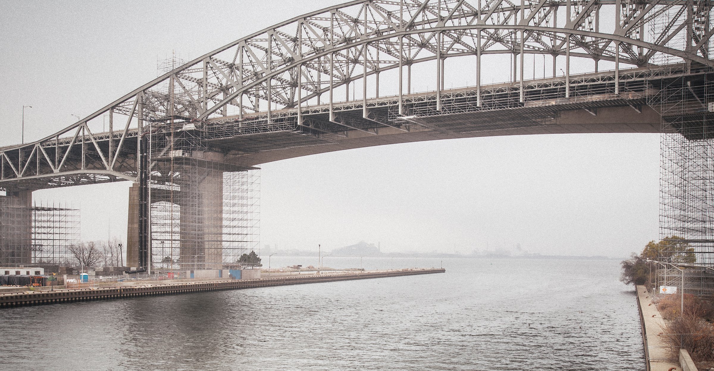
City Between Stories — The Skyway Over Hamilton Harbour @Solomon D Crowe
The QEW Skyway cuts a high arc over the water in Hamilton, Ontario, its temporary scaffolding revealing a larger civic truth: the most essential structures—physical and human—often do their work quietly, supporting an entire region without demanding the spotlight.
There are crossings in Southern Ontario that don’t feel like travel so much as calibration. The air cools. The lake widens. The horizon turns spare and pale, the kind of overcast that flattens color into a single disciplined tone. From below, the Skyway’s steel geometry reads like a sentence written in trusses—an argument for connection, for speed, for the simple belief that distance should be conquered. And then you notice what interrupts the clean line: the lacework of scaffolding, the temporary lattice that clings to the span like a second nervous system. It doesn’t tell you what’s being changed or why; it simply reveals a truth we spend most of our lives trying not to see—that the built world is not static, that permanence is borrowed, that every “normal day” depends on structure you rarely think about until something forces you to look up. The water beneath the bridge doesn’t care about schedules or reputations. It just moves. And the city on either side—Hamilton—keeps doing what it has always done best: carrying the load while other places take the credit.
Hamilton is a city most people think they know without ever really knowing it. They know it as a waypoint on the drive: between Toronto’s gravity and Niagara’s romance; between boardrooms and vineyards; between the airport run and the weekend rental; between a place you “go” and a place you “get through.” It’s a dangerous kind of familiarity, because it makes a city disappear in plain sight. The most consequential places are often like that: not the headline, but the hinge; not the brand, but the backbone. Hamilton doesn’t just sit inside the Golden Horseshoe—it absorbs its pressure. It holds commuters, industry, hospitals, ports, campuses, and the second-order realities that keep a megaregion functioning when the spotlight is pointed elsewhere. If Toronto is the narrative people sell, Hamilton is the infrastructure people rely on. And the older you get, the more you realize that “rely on” matters more than “look at.”
That in-between status is so baked into Hamilton that even its nicknames read like competing biographies. “Steeltown.” “The Ambitious City.” “The Hammer.” Names that swing between pride and defensiveness, between industrial muscle and reinvention, between the city Hamilton was and the city it keeps insisting it can be. You can hear the tension in them: a place that refuses to be reduced to a single chapter, but also refuses to pretend it doesn’t have roots. Those roots matter because they explain Hamilton’s posture—why it doesn’t perform the way glossy cities perform, why it can feel blunt, why it sometimes seems more interested in function than applause. When a place has been measured for generations by output—by what it produces, what it ships, what it services—it develops a different relationship to image. It learns to distrust the cosmetic. It learns that what holds is more important than what sells.
The temptation, when you say “Hamilton,” is to make it all about steel. That’s the easy shorthand, and it’s not wrong—just incomplete. Companies like ArcelorMittal Dofasco trace their roots in Hamilton back to 1912, and Stelco’s corporate story runs deep in the city’s industrial lineage; for decades, steel wasn’t just an industry here, it was an identity—an entire social ecosystem of shifts, paycheques, lunch buckets, union debates, air quality arguments, pride, and fatigue. But what makes Hamilton truly current—truly “today”—is the way it has diversified without erasing itself. The city’s economic centre of gravity has been evolving toward health, education, research, and life sciences in ways that don’t always show up in outsider conversations. “Life sciences” can sound like brochure language until you remember what it actually means on the ground: hospitals, clinical trials, labs, biotech, and the infrastructure of care. Invest in Hamilton describes the sector as a “powerhouse of innovation and research,” and the region’s health institutions and university ecosystem give that claim weight beyond marketing. McMaster continues to pull research investment and economic activity into the city, and Hamilton Health Sciences is consistently positioned as a major employer and anchor of the local workforce. This matters for an honest editorial because it reframes what “a working city” looks like in 2026: not only smokestacks and mills, but operating rooms, research grants, and the steady logistics of keeping people alive.
Then there’s the cultural story—the one outsiders often miss because it doesn’t arrive packaged as a skyline. Hamilton’s creative identity has matured into something that doesn’t need permission. Supercrawl, founded in 2009 by Hamilton artists and community builders to showcase the city’s cultural vibrancy, didn’t just create a festival; it helped establish a new civic self-image—one rooted in street-level life, music, art, food, and public presence rather than corporate spectacle. By the organizers’ own reporting, Supercrawl in 2025 covered 22 city blocks and attracted more than 285,000 visitors, which is the kind of scale that quietly rewrites what a “second city” is allowed to be. And Hamilton’s streets have become more than stages for its own events—they’ve become sets for other people’s narratives, too. Tourism Hamilton openly maps the city’s filming locations, pointing out how productions use its architecture and downtown textures as versatile stand-ins for elsewhere. A place can be flattered by that, but Hamilton’s deeper trick is subtler: it can host other stories without losing its own. Even the infrastructure that supports filming—the studios, the equipment ecosystem, the location support—signals that this isn’t a fluke, it’s a working creative economy with its own supply chain.
This is where the scaffolding in the photograph becomes more than a literal structure. It becomes a thesis. Hamilton is a scaffolding city in the best sense: the support system people depend on but rarely praise. Not glamorous, not always tidy, but essential. Consider what happens here every day that most people don’t emotionally register. Port operations move quietly at the edge of the public imagination, yet the Port of Hamilton handles over 12 million tons of cargo and sees hundreds of vessel visits each year—numbers that translate into food inputs, fuel, construction materials, industrial components, and the less poetic realities that keep households and businesses functioning. Hospitals absorb the region’s emergencies with routines so practiced they can look effortless from the outside, even when they are anything but. Universities and research networks turn the city into a lab for health innovation and a magnet for specialized talent, and those gains ripple outward into suppliers, housing demand, and small businesses that live or die by whether people show up year-round, not just on festival weekends. The point isn’t to turn this into an “industry” editorial; it’s to name a human truth: modern life runs on layers of unseen competence, and Hamilton is one of those layers for the entire region.
And yet, the most important scaffolding Hamilton provides isn’t cargo tonnage or institutional capacity. It’s psychological. Hamilton is where the myth of effortless prosperity gets replaced by the more adult idea of endurance. It’s where you can still feel the cost of things—housing, time, labor—without the city trying to distract you with constant gloss. That is precisely why more people are drawn to places like Hamilton now: not because they want less ambition, but because they want ambition that doesn’t require performance. The City of Hamilton notes that the population increased to 569,355 in 2021, up more than 32,000 from 2016—growth that reflects how the region’s pressures are redistributing people and decisions across the map. Zoom out, and Statistics Canada’s CMA population estimates show Hamilton’s broader metro area continuing to rise—another signal that the “in-between” is becoming its own gravitational field, not merely overflow. For years, research and policy work have pointed to spillover dynamics in housing markets around the GTA—how price pressure and demand radiate outward, reshaping nearby communities. CMHC has explicitly examined GTA house price spillover effects on Hamilton, which is one of the cleanest institutional ways to say what many residents have felt personally: people don’t just move here for charm; they move here because the math of the region forces choices.
That redistribution creates tension, and any editorial that aims to be honest has to sit inside the tension without preaching. Growth can energize a city and also strain it. New investment can revive streets and also price out long-time residents. A creative renaissance can feel like rebirth to some and erasure to others. Hamilton, more than many places, is living that contradiction in real time because it’s close enough to Toronto to catch the wave, but different enough to resist becoming a replica. This is where the “city between stories” framework becomes useful: Hamilton is not finishing one story and starting another; it’s holding multiple stories at once—industrial legacy, health and research expansion, cultural confidence, housing pressure, and the quiet daily labor of staying functional. The mistake outsiders make is trying to reduce it to a single narrative: “steel city,” “revival city,” “spillover city.” Hamilton is all of these and none of them, depending on which street you’re on and what time of day you arrive.
So what does it mean to write a travel-and-culture editorial about Hamilton using a bridge as the visual anchor, without becoming trapped by the bridge itself? It means treating the image the way strong editorial photography is meant to be treated: as a doorway, not a destination. The Skyway’s arc becomes a metaphor for every adult crossing happening in the region right now—people shifting careers, downsizing homes, moving closer to aging parents, choosing a smaller city without choosing a smaller life. The water under the span becomes the quiet counterpoint to the noise of the corridor, a reminder that movement is constant whether you name it or not. The scaffolding becomes the most honest symbol in the frame: a visible acknowledgment of the supports we depend on and rarely celebrate, from bridgework to shift work, from public services to the invisible emotional labor people spend keeping families and communities intact.
Hamilton deserves a different kind of attention than it usually gets—not the attention that turns a place into a trend, but the attention that recognizes value before it needs to be marketed. If you come here only looking for “things to do,” you’ll miss the point. The deeper travel experience is learning how a region actually runs, and why some cities become indispensable precisely because they aren’t constantly posing for the camera. Hamilton is not a detour. It’s an answer to a question the Golden Horseshoe is increasingly being forced to ask: what happens when growth outpaces glamour, and the future depends more on support systems than on skyline shots? The honest reply is that the future starts in hinge cities—the places between stories—where people build lives that don’t require applause, only stability, opportunity, and a little room to breathe.
Before Calgary Was a Skyline, It Was a Schedule
In a decade ruled by invisible systems—feeds, files, frictionless purchases—a working steam locomotive is a shock of honesty. CPR 2024 doesn’t exist to be “content.” It exists to be maintained. And in Calgary, a city born from timetables and rail geometry, that maintenance becomes an argument with the modern world: the future still depends on what we’re willing to keep running.
CPR 2024: The West on a Working Loop
A steam locomotive lettered 2024 operates at Heritage Park in Calgary—painted in Canadian Pacific’s pre‑1915 livery despite never being owned by the CPR. Built in 1944 by Lima Locomotive Works for U.S. Army service and later sold as surplus to Pacific Coast Terminals in 1947, the engine now runs Heritage Park’s 4,300‑foot standard‑gauge loop: a living demonstration that the West was built on water, steel, maintenance, and time.
There are places where history is curated behind glass—quiet, climate‑controlled, politely distant. And then there are places where history still sweats. Where it still consumes fuel and water. Where it still demands hands, timing, and a kind of humility that the modern world keeps trying to delete. Standing beside a working steam locomotive is not the same as looking at one. The difference is physical: vibration through the soles, the faint metallic tang in the air, the way your brain re-calibrates when confronted with a machine that refuses to be “content.” It doesn’t want to be liked. It wants to be maintained. It wants to be understood. And in a decade when most of our days are spent shuttling invisible files across invisible networks—rent, health care, layoffs, mortgages, meetings that evaporate the moment they end—something inside an adult audience recognizes the relief of a system you can actually see.
The engine in this frame wears a number—2024—like a badge and a dare. Not a year, not a marketing hook, but a designation that signals how museums sometimes stitch together story and system to make the past legible again. At Heritage Park in Calgary, Locomotives 2023 and 2024 are painted in Canadian Pacific’s pre‑1915 livery even though they were never owned by the Canadian Pacific Railway. Their road numbers were chosen because they fit “blanks” in the CPR numbering system of that era, a curatorial decision that tells you something important: history is never only what happened; it’s also how we decide to remember it. That choice isn’t deception—it’s translation. It’s an invitation for the public to read an artifact within the visual language of the West that built Calgary, a region that learned early that identity is often carried by infrastructure.
But the deeper truth is that 2024 is not a prop. It is a veteran of a different kind of war—one fought with logistics, steel, and standardized design. Heritage Park documents that both engines were built in the 1940s to a standard United States Railway Administration design and were intended for U.S. Army service in the Far East: #2024 was built in 1944 at the Lima Locomotive Works in Lima, Ohio, and #2023 in 1942 by ALCO in Schenectady, New York. When the world reordered itself after WWII, the engines were sold as surplus to Pacific Coast Terminals in Vancouver in 1947, then worked for 18 years as yard engines on the wharves at New Westminster, British Columbia—the kind of work that rarely becomes legend but makes legend possible: switching cars, feeding ports, keeping commerce from stalling. In 1965, as they were being scrapped, a private citizen bought them, and they were eventually resold to Heritage Park, where the museum’s stated aim is to keep them in active service “for generations to come.” That single arc—war design to industrial drudgery to preservation—contains a whole philosophy of North American life: build fast, use hard, forget quickly, and then, years later, realize what you’ve lost.
To understand why this matters in Calgary, you have to understand what the railway did to the idea of distance on the Prairies. Calgary’s modern story is often told through oil booms, corporate towers, and the Stampede spectacle, but the spine of the city—the thing that turned a remote fort into a place that could scale—was rail. The Canadian Encyclopedia notes that the railway reached Fort Calgary in 1883, and the CPR subsequently laid out the Calgary townsite west of the Elbow River, a planning decision that shaped the city’s core and its future. When people say “Calgary was built on the West,” that phrase can feel like romance—until you recognize it as a literal description of settlement patterns, supply routes, and the economic geometry rail imposed on the landscape. Alberta’s own energy‑heritage history resources describe the arrival of rail transportation in the late nineteenth century as one of the most important developments in modern Alberta’s history, noting again that the Canadian Pacific reached Calgary in 1883. Calgary didn’t just grow; it was connected into existence.
And Canadian Pacific itself—still one of the most consequential corporate authors of the country’s geography—frames its founding in 1881 as a project to link Canada’s populated centres with the “vast potential” of the West, completed when the “last spike” was driven on Nov. 7, 1885 at Craigellachie, B.C. Whatever you think of the politics and consequences of that nation‑building story—and adults increasingly hold more than one truth at once—you can’t deny the mechanical reality: rail was the technology that made “Canada” operational at scale. That is why a working steam engine, circling a heritage loop in Calgary, is not nostalgia. It is a reminder of the original operating system.
Yet there is a harder layer beneath the romance, and serious storytelling can’t dodge it. Heritage Park explicitly acknowledges that it sits on Treaty 7 territory, recognizing the deep historical connection to the land by the Blackfoot, Tsuut’ina, Îyârhe Nakoda, and Métis peoples and positioning itself as a place where Indigenous people share traditions and tell stories about heritage and attachment to the land. That matters here because railways didn’t only deliver mail and cattle cars; they delivered a new order—new property lines, new enforcement, new economies, and new pressures on the people who were already here. For adult readers, this is not a footnote. It is the cost line in the ledger. The West was built, yes—but it was also taken, re‑mapped, and administrated. A locomotive can be a marvel and a witness at the same time.
This is where the story stops being about a preserved engine and becomes a state‑of‑affairs editorial for right now. Because our current era—despite all its “innovation”—is suffering from a crisis of comprehension. We live inside systems we cannot see and therefore do not trust. Food arrives without us understanding the chain. Packages land on porches like magic. Money moves as numbers, then disappears as fees. Work becomes an endless scroll of dashboards. Even politics has been flattened into feeds: loud, fast, and forgettable. The adult nervous system is exhausted by abstraction. So we seek places where the world is re-materialized—where cause and effect are visible again. That is the hidden power of operational heritage: it re-teaches the public what a real system costs, what it consumes, what it requires to keep going.
Heritage Park’s railway was unveiled in 1964 specifically to keep a working example of the transportation that had the greatest effect on the history of western Canada. The park’s collection includes nearly 30 pieces of rolling stock from multiple railways, built between 1882 and 1949, running on standard gauge track with 100‑pound rail and a main loop 4,300 feet long. Those numbers are not trivia; they are the language of constraint. And then there’s the most telling detail of all: water. Heritage Park notes that locomotives 2023 and 2024 each have a water tender capacity of 3,000 gallons, and when in use, one of these engines travels approximately 72 kilometres in a single day on the park’s track, using between 1,600 and 1,700 gallons of water. Every morning, the engine is filled from a water tower the park built in 1973 from a 1902 CPR plan, with pipes and valves salvaged from a retired water tank at East Coulee, Alberta, east of Drumheller. In a world where we argue online about “efficiency” like it’s a personality trait, a steam locomotive makes you confront efficiency as physics. It eats resources. It turns them into motion. And it does not pretend otherwise.
That is why this kind of image—steam, steel, a human in the cab—lands with adults who are not looking for a theme park. They are looking for orientation. The engine’s story carries a quiet indictment of our present: we’ve optimized for convenience and lost reverence for the infrastructure that makes convenience possible. We don’t maintain relationships; we “replace” them. We don’t repair objects; we “upgrade” them. We don’t preserve institutions; we starve them until they become content or collapse. Heritage Park, by contrast, describes a planned maintenance program aimed at ensuring these engines will see active service for generations. That is not merely a museum practice. It is a counter‑ideology: care is the opposite of disposability. And care, at the adult level, is what most of us are starving for—care from systems, from leadership, from communities, and from ourselves.
There is another reason this locomotive hits a nerve: it’s a working metaphor for midlife. Not in the cliché sense—no self‑help slogans, no “live laugh love”—but in the real sense of resource accounting. Adults eventually learn that momentum is never free. Something always fuels it: time, sleep, health, attention, money, someone else’s labor. Steam power makes that truth visible. The water tower, the daily fill, the valves and pipes, the tender capacity—these are not decorative elements. They are the receipts of movement. The West that Calgary inherited was built by people who understood receipts because they couldn’t outsource consequences to the cloud. When the water froze, the line froze. When the siding didn’t exist, the town didn’t exist. When the timetable failed, the economy failed. That doesn’t mean the past was better. It means the past was less deniable. In 2025, deniability is everywhere—and it is making us anxious.
So when you place this photograph on a page, the goal isn’t to “teach people about trains.” The goal is to remind them what they already know but have been trained to forget: that every functioning life is a network of maintained systems. Calgary’s origin story is proof. The CPR arrives in 1883, the townsite shifts, the city’s core takes shape; the line becomes the spine. Later, other engines, other fuels, other booms arrive. But the underlying pattern stays the same: the West runs on coordination. On logistics. On people doing unglamorous work with disciplined repetition. In an era that celebrates only the visible—followers, brand deals, virality—this is a radical message: the most important work is often the work nobody photographs.
And yet here we are, photographing it—because the camera, at its best, is not a machine for prettiness. It’s a machine for attention. A good editorial image doesn’t just show you a subject; it shows you a structure. The conductor in the cab—anonymous to most viewers, essential to the machine—becomes a stand‑in for every human role modern life treats as background: operators, maintainers, schedulers, mechanics, dispatchers, the invisible hands that keep cities from stalling. The locomotive’s number—2024—becomes a reminder that identity is sometimes assigned for coherence, not because the artifact is lying, but because the audience needs an entry point. And the setting—Heritage Park, a place built explicitly to keep the West’s story operational—becomes the stage where the past isn’t merely remembered; it is rehearsed, so the present can see itself more clearly.
If you want this editorial to travel—if you want it to reach beyond railfans and into the bloodstream of people who haven’t thought about a locomotive since childhood—then the hook is not steam. The hook is trust. The hook is maintenance. The hook is the ache adults carry when they realize the world is run by systems they can’t audit. And the quiet comfort they feel when confronted with a machine that can’t hide what it needs: water, heat, care, and time. Calgary was built on the uncompromising logic of those needs. This locomotive is not a toy echoing the past; it is a working argument with the present. It asks: what happens to a society when it stops valuing the people who keep it running? What happens when we treat maintenance as a cost instead of a virtue? What happens when we forget that every “modern miracle” rests on a timetable somebody still has to keep?
The answer, in part, is why images like this matter. They don’t solve the crisis. They don’t fix the systems. But they restore the viewer’s ability to feel something accurate: respect for what’s real, and suspicion of what’s frictionless. They bring us back to the West’s original lesson—Calgary’s first lesson—that momentum is built, not wished for. That distance is conquered by cooperation, not commentary. And that the most durable progress is the kind you can still ride decades later, because someone cared enough to keep the machine alive.
The Stranger Next to You
On a wet afternoon in Potsdam, strangers move shoulder to shoulder beneath umbrellas, sharing space without sharing presence. This editorial examines what modern cities reveal about proximity, privacy, and the quiet thinning of public life.
The Stranger Next to You @Solomon D Crowe
Pedestrians move in loose formation beneath umbrellas along a Potsdam sidewalk, sharing public space with cars and cyclists while remaining sealed inside private rhythms—an everyday scene that captures how modern cities train people to travel together without truly meeting.
On a wet afternoon in Potsdam, the sidewalk becomes a moving compromise. A loose cluster of umbrellas advances along the curb, their canopies overlapping and separating in the same rhythm as the people beneath them—close enough to share air and pace, far enough to remain unclaimed. Traffic idles nearby, bicycles slip through the background, and the street’s instructions hang above the scene in clean European geometry: a red triangle warning, a blue circle directing, signals rationing time. There is a license plate with a single letter that quietly gives the city away—“P,” the code for Potsdam—an administrative detail that feels almost poetic in context because it reduces a whole place to one character, the same way modern life has reduced countless human encounters to glances that don’t land. The group moves forward with the practiced efficiency of people who have walked past one another for years without ever meeting. It is not loneliness in the melodramatic sense. It is something more familiar and harder to name: proximity without contact, togetherness without claim, public life conducted at a distance even when bodies are close enough to brush sleeves.
What’s visible in moments like this—more visible than we like to admit—is how modern privacy has migrated out of buildings and into behavior. We used to think of privacy as walls, doors, and rooms. Now it is posture, pace, and what you choose not to notice. The umbrella is a literal version of the trend: a portable ceiling, a small boundary that says, “I’m here, but I’m not available.” The same logic exists everywhere else on the street. Headphones are a social gate. The phone held low is a shield. The eyes that stay forward are a kind of quiet contract: we will share the sidewalk and spare one another the obligation of acknowledgment. It isn’t cruelty. It’s economy. Each person carries a day’s worth of tasks, alerts, news, and mental tabs, and the smallest interaction—eye contact, a greeting, even a moment of courtesy—can feel like one more demand. Over time, these micro-avoidances become a culture of movement. People learn how to live among strangers without being touched by them, and the skill becomes so common it starts to feel like the natural state of cities, as if sidewalks were built for bodies rather than for human beings.
But public life has not always operated this way, and it doesn’t operate this way everywhere. Potsdam is a city that, on paper, should resist private-world drift. It is built around walkable scale and layered history, where parks and routes connect neighborhoods with the kind of everyday beauty that encourages lingering. Even the street signage tells you the city expects you to move through it slowly enough to choose a direction: a cycling route labeled “Alter Fritz,” named for Frederick the Great, points outward toward a UNESCO-laced landscape that is meant to be traversed rather than consumed. Yet even here—even in a place where the built environment still invites public life—the dominant mood of modern streets is increasingly one of parallel solitude. People are physically near one another, but socially sealed. The paradox is that the more “connected” we become through devices and platforms, the more we rehearse disconnection in the spaces that once taught us how to be citizens of each other’s presence.
That paradox is no longer merely a cultural observation; it has become a matter of public health and public policy. The World Health Organization’s Commission on Social Connection has described loneliness as widespread globally, reporting that roughly one in six people experience it, with higher prevalence among adolescents and young adults. In the United States, the Surgeon General’s advisory on social connection framed the stakes in blunt terms, linking loneliness and social isolation to increased health risks and treating social connection as a protective factor rather than a sentimental luxury. Europe, too, has been measuring what used to be dismissed as subjective. The European Commission’s Joint Research Centre reported, based on an EU-wide survey, that in 2022 more than a third of respondents felt lonely at least sometimes and 13% felt lonely most of the time—numbers that turn the private ache of disconnection into an infrastructural concern. Germany has gone further, commissioning a national “Loneliness Barometer” to track long-term trends, a move that signals the issue has crossed from personal psychology into the domain of governance. The OECD has also pointed to measurable deprivations in social connectedness across wealthy countries, including shares of people who feel unsupported, report having no close friends, or experience loneliness frequently—evidence that the decline of everyday social fabric is not confined to one nation or one kind of city. In other words, the stranger beside you is no longer just a social fact of urban life; the widening gap between bodies and belonging is being treated as a structural risk.
If that sounds abstract, the street makes it concrete. The modern sidewalk has become one of the last remaining “commons” where people must share space regardless of ideology, income, or identity, and that forced proximity is precisely what makes it revealing. We can debate polarization, mental health, and the effects of the internet in essays and studies, but the daily proof lives in small behaviors: whether someone holds a door; whether a group makes room; whether a cyclist signals; whether a pedestrian acknowledges the near-collision that did not happen. These are not personality quirks. They are outputs of systems. Digital life trains attention to fragment and flit; platforms reward instant reaction more than slow recognition; and the smartphone—now nearly universal in some countries, and psychologically hard to set aside—turns every spare moment into an opportunity for stimulation. In the U.S., Pew reports that about nine-in-ten adults own a smartphone, and a significant share describe their internet use as almost constant; the exact numbers matter less than the pattern they document: a society trained to fill every gap with input. Meanwhile, the city itself has changed the terms of encounter. Rising costs push people into longer commutes and tighter schedules; service work and shift work distort the old “shared hours” when neighbors once overlapped naturally; and the decline of civic institutions and regular group participation—documented repeatedly in contemporary reporting—reduces the number of places where strangers become familiar faces. When life is organized around efficiency and consumption, the casual, unplanned conversation becomes an endangered species.
And yet, the photograph also hints at the counter-story: public life hasn’t disappeared; it has become thinner, more fleeting, and easier to miss. Even in a crowd moving forward with heads down, the street still produces moments of involuntary coordination. Someone subtly angles an umbrella to avoid hitting a neighbor. A person at the edge of the group slows for an older walker without making a show of it. A cyclist waits at the light because the signal is red, not because a camera is watching. A pedestrian steps closer to the hedge to allow another to pass—an act so small it would never be called kindness in conversation, yet it is exactly the kind of micro-consideration that keeps cities livable. These gestures rarely result in friendship, and that is not the point. Their function is civic, not intimate. They reaffirm a basic premise: that strangers can share space without hostility, that cooperation can be habitual rather than negotiated, that the public realm still contains a thin thread of mutual recognition even when everyone seems sealed into private worlds. Places like Potsdam—where the built environment still supports walking and cycling routes that link neighborhoods and landmarks—quietly increase the odds that this thread survives because they keep people in the same physical frame long enough for courtesy to occur. A city designed for cars can move people. A city designed for bodies can still, occasionally, connect them.
This is why the “stranger next to you” has become such a potent figure in contemporary life. The stranger is the test of our civic muscles. Family and friends don’t tell you whether a society is functioning; private affection can thrive even in a broken public realm. The stranger tells the truth. If strangers can share a sidewalk with grace, if they can yield and navigate without aggression, if they can look up long enough to notice each other as real, then public life has not fully collapsed into private broadcast. And if they cannot—if every encounter is treated as interference, if every shared space becomes a competition, if every person becomes an obstacle—then the city is still standing but the society inside it is thinning. The most unsettling part is that neither outcome is inevitable. The data points from health agencies and governments, from EU surveys and national barometers, suggest the stakes are rising; loneliness is being measured because it is now too widespread to ignore. But the street-level reality suggests something else as well: the solution is not likely to arrive as one dramatic cultural reversal. It will arrive, if it arrives at all, as a million small corrections—more places that reward lingering, fewer systems that punish unstructured time, and a renewed social tolerance for being briefly available to the people beside us.
In the end, the sidewalk does not ask anyone to become a hero of community. It asks something smaller and more realistic: to remain human in public. To share space with competence. To recognize that the private world you carry—your phone, your worries, your schedule, your internal soundtrack—does not cancel the fact that you are moving through a shared environment built by others and sustained through cooperation. That is the quiet discipline of city life, and it is easy to lose when everything else trains you to be alone together. The stranger next to you may never become your friend. But the stranger is still part of your world, and the future of public life depends, more than we like to admit, on what happens in the brief, unrecorded moments when our umbrellas overlap and we choose, instinctively, whether to make room.
When the Region Comes Home: GO Trains, Downtown Toronto, and the New Commute After Dark
After dark in downtown Toronto, GO Transit trains line the rail corridor near Rogers Centre, revealing how regional rail has become essential infrastructure for a city shaped by housing pressure, extended commutes, and a workforce spread far beyond the core. This editorial examines how Toronto now functions not just as a city, but as a region held together by rail.
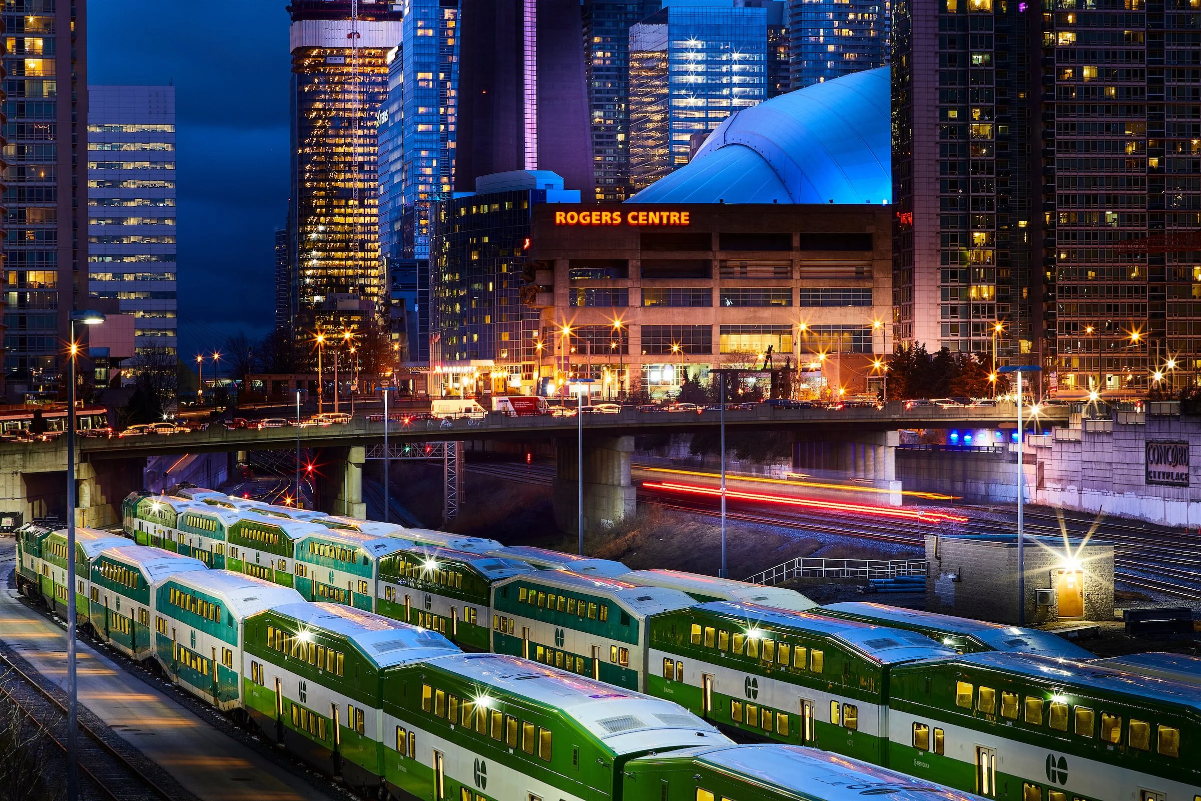
GO Transit Trains at Rogers Centre, Downtown Toronto at Night @Solomon D Crowe
GO Transit trains line the rail corridor beside Rogers Centre in downtown Toronto at night, as city traffic and illuminated high-rise buildings frame the intersection of regional rail infrastructure and the urban core. The scene reflects Toronto’s dependence on regional transit systems to support commuting, housing displacement, and after-hours city operations in Canada’s largest metropolitan area.
Toronto’s most revealing hour isn’t the morning rush, when the city performs efficiency for itself, nor the late afternoon surge, when sidewalks thicken and the streetcar platforms fill with impatience. It’s the quieter interval after the lights of spectacle have done their job—after the game, after the concert, after the last downtown dinner reservation—when the skyline keeps shining but the city’s true operating model becomes visible. In that hour, movement stops being a lifestyle and returns to what it has always been in a metropolis this large: a requirement. You can see it in the way traffic continues to stream along elevated concrete, in the way rail corridors hold their lines through the core, and in the way trains wait like coiled infrastructure, not romantic symbols but practical promises. This is the Toronto that doesn’t fit neatly into postcard narratives. It is a Toronto made of systems—housing, labor, transit, and time—and a region that now moves through the city the way blood moves through a heart: repeatedly, relentlessly, and because there is no alternative.
What the image captures, at a glance, is a modern urban truth that increasingly defines life across the Greater Toronto and Hamilton Area: Toronto is not simply a place people move within; it is a place people move through, often over distances that would have been considered absurdly far a generation ago. That shift isn’t driven by wanderlust. It’s driven by math. In a market where housing costs have restructured where families can live, and where economic uncertainty has kept both buyers and sellers cautious, the region has been forced to stretch. Even as affordability has improved in certain periods through price declines and lower borrowing costs, the underlying reality remains: many households are still making high-stakes trade-offs between space, cost, and commute time. Reuters reporting on recent Greater Toronto Area housing data underscored the continued volatility and uncertainty in the market, including month-to-month price and sales shifts and a broader climate shaped by economic confidence and external pressures. The result is not merely a longer commute. The result is a new geography of daily life in which the distance between where people earn and where they can afford to live has become normalized, and rail has become one of the only tools capable of making that normalization survivable at scale.
This is where GO Transit becomes more than transportation and starts functioning as civic scaffolding. The network is often discussed as though it is an accessory to downtown Toronto—a commuter convenience tethered to the core. But the lived reality is more consequential. GO functions as an equalizer for some and a necessity for many, compressing a wide region into timetables and platforms, turning what would be a destabilizing sprawl into something closer to a working system. Metrolinx has been explicit about the direction of travel: GO Expansion’s stated goal is to build the capacity for service every 15 minutes or better, all-day, in both directions on core routes, transforming the network from a peak-only commuter model into a regional backbone. That ambition speaks directly to the shift that Toronto now embodies: a core economy supported by a distributed workforce. The skyline is still where the brands live, where the institutions concentrate, where the spectacle gathers. But the workforce and the cost of living are increasingly distributed outward, and a functional transit spine becomes the difference between a city that grows and a city that fractures.
Ridership data supports that story in a way no editorial flourish can. In Metrolinx’s 2024–25 annual reporting, GO Transit and UP Express ridership rose to 71.8 million, a year-over-year increase of 21.6 percent, with weekend and off-peak travel showing striking strength compared to 2019 benchmarks. That matters because it signals that the network is not simply “coming back” to a pre-pandemic commuter pattern; it is evolving into something broader, with leisure and off-peak movement increasingly part of the load it must carry. Metrolinx has also highlighted that 2025 included multiple service increases, including first-ever weekend service to Kitchener, a notable marker in a region where the Kitchener line has long represented the outer edge of what “reasonable commuting” used to mean. Read plainly, this is the region voting with its feet: not just commuting to work, but moving for life—visiting family, attending events, accessing services, making the city’s cultural core usable without requiring everyone to live next to it.
Yet a network that carries more life also inherits more friction, and in Toronto the friction has often lived in the seams between agencies. For years, one of the least glamorous but most punishing barriers to transit use in the GTA has been the penalty of transferring—paying again to cross invisible jurisdictional lines. That is why the province’s One Fare program mattered immediately, not as branding but as a direct reduction of commuter pain. Beginning February 26, 2024, One Fare eliminated double fares for riders transferring between GO Transit and participating local systems, including the TTC, and was positioned by the province as a measure that could save frequent riders meaningful money over the course of a year. Metrolinx’s program detail makes the mechanics concrete: for trips connecting between TTC and GO Transit, the TTC component becomes effectively free via the fare integration discount. This is not a poetic policy change; it is a structural one. It acknowledges, in dollars and transfers, the reality that Toronto is a multi-system commute for countless riders—and that the region cannot pretend seamless mobility while charging people for the act of stitching systems together.
The long view, however, is where Toronto’s transit story becomes both ambitious and precarious. GO Expansion is not just about frequency; it is also about building the physical and electrical capacity required to run a denser schedule reliably. That means corridor works, grade separations, station modifications, and the slow, expensive, politically exposed work of electrification. Some of that progress is visible only in technical updates and utility relocations that most riders will never notice until the day service changes. For example, one utility provider’s project update tied to GO Expansion rail electrification described a phased timeline in which work began in 2024 and a next phase was tentatively scheduled to begin in April 2026. Meanwhile, municipal documents tracking GO Expansion elements have noted areas where timelines remain uncertain and where tendering and construction sequencing can shift. This is the reality of big-city infrastructure: it is never only engineering. It is procurement. It is community impact. It is political patience. It is the gap between what a region needs and what it can build quickly enough to keep up with that need.
Set against that slow churn of infrastructure is the faster, louder economy of downtown entertainment—the part of Toronto that broadcasts itself to the world. The Rogers Centre sits at the edge of that mythology, a landmark where crowds concentrate and the city’s image is staged in bright, commercial language. In recent years, that landmark itself has been rebuilt as part of a high-profile, multi-year renovation measured in the hundreds of millions of dollars, designed to modernize the venue and reshape the fan experience. This is where Toronto’s dual identities collide in the same frame: above, the city as spectacle; below, the city as system. Stadium lights, condo windows, and nightlife narratives are what people tend to remember. But the region’s daily viability depends on what happens when the event ends—when staff, fans, and workers disperse into a commuter geography that is larger than any one neighborhood, larger than any one subway line, and increasingly defined by rail corridors that must absorb surges without collapsing into gridlock.
That is why the trains waiting beside the core matter as a symbol that stays honest. They are not merely “parked.” They are staged for repetition—cleaned, checked, queued, and returned to the cycle. They represent the city’s wager that tomorrow will be possible for people who do not live close to where the city concentrates its wealth and opportunity. They are the physical infrastructure behind the abstract phrase “regional economy,” a reminder that economic centralization requires mobility to function, and that mobility requires sustained public investment even when the most visible parts of the city are doing just fine. This is the part of the urban story that rarely goes viral because it isn’t framed as crisis. But it is the story that explains, more accurately than skyline photos ever will, why so many people feel that modern city life has become an endurance sport. The region comes home each night, not in one dramatic wave, but in thousands of individual returns, distributed across lines and platforms and timetables, stitched together by a network that must perform whether the city is celebrating or simply trying to make it to morning.
If you want to understand where Toronto is heading, you do not start with the newest tower or the loudest headline. You start with the systems that must hold under pressure. You start with ridership returning and changing shape, with fare integration reducing friction at the seams, with expansion plans promising frequency that the region now demands, and with electrification and corridor works unfolding at the pace of real infrastructure, not wishful timelines. Then you look back at the skyline and the stadium and recognize them for what they are: not the whole story, but the most visible part of a much larger machine. The trains waiting in the night are not just vehicles. They are evidence of the regional contract Toronto is now living under—a contract in which distance has been normalized, mobility has become a form of affordability, and the city’s future depends on whether its infrastructure can keep up with the life it has already created.